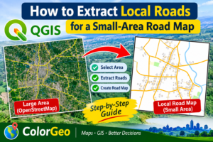
A practical step-by-step guide using OpenStreetMap and QuickOSM in QGIS 3.44
In this tutorial: download mapped roads, clip them to a study boundary, classify road types, check data quality, and prepare a clean map for PDF, SVG, or PNG export.
1. Introduction
A detailed road map is useful for local planning, field surveys, accessibility studies, disaster-risk assessment, service-area mapping, and community-level GIS projects. For a small area—such as a village, union, municipality, or university campus—you can obtain an initial road network from OpenStreetMap (OSM) and process it in QGIS. This guide explains a straightforward workflow using the free QuickOSM plugin. The method is suitable for QGIS 3.44. The exact amount of road detail depends on what has already been mapped in OpenStreetMap.
2. What you need
QGIS 3.44 or a compatible recent QGIS version.
An internet connection for querying OpenStreetMap data.QuickOSM plugin installed in QGIS. A study-area boundary layer (recommended), such as a village, union, municipality, or campus boundary. If you do not have one, you can use the QGIS map-canvas extent.
3. Install the QuickOSM plugin
Open QGIS.Choose Plugins → Manage and Install Plugins.Search for QuickOSM.Select QuickOSM and click Install Plugin. Open it from Vector → QuickOSM → QuickOSM, or use the QuickOSM toolbar button if it is visible. QuickOSM sends queries to the OpenStreetMap Overpass service and loads matching features into QGIS. The service may be busy or impose query limits, so very large requests can take longer or fail.
4. Prepare the study area
Option A:
Use a boundary layer (recommended) Add your study-area polygon to QGIS. This may be a village, union, municipality, or campus boundary. A boundary layer makes it easier to clip the downloaded roads precisely to the area you want to map.
Option B:
Use the map canvasIf you do not have a boundary polygon, zoom the QGIS map canvas to the required area. QuickOSM can use the current canvas extent as the query area. Leave a small margin around the area if roads close to the boundary are important.
5. Download roads using QuickOSM
For a first extraction, use the following settings in the QuickOSM query panel:
QuickOSM field Setting
6. Understand the OpenStreetMap highway classes
7. Clip the road network to your boundary
If you downloaded roads for a larger extent, use the Clip tool to keep only the parts inside your study-area polygon.Open Processing → Toolbox.Search for Clip (Vector overlay). Set Input layer to the downloaded road line layer. Set Overlay layer to your study-area polygon. Choose an output file and run the tool.The output is a road layer limited to the polygon boundary. If you do not have a polygon boundary, you can keep the canvas-extent download or create a study-area polygon first.
8. Review and clean the road data
Before styling the map, inspect the attributes and geometry:Open the road layer’s attribute table and confirm that the highway field is present. Use Select by Expression or the layer filter to review specific road classes. Check for duplicate features, unexpected lines, and features outside the intended study area. Inspect road connections and gaps against recent imagery or other reliable reference data. Do not delete a feature solely because it looks unusual; verify it first.For more advanced cleaning, QGIS Processing tools such as Delete duplicate geometries, Fix geometries, and Dissolve may be useful in suitable cases. Use them carefully and keep an unchanged copy of the downloaded source data.
9. Style roads by category
Categorized symbology helps readers distinguish the road hierarchy. Right-click the clipped road layer, choose Properties → Symbology, select Categorized, choose highway as the Value field, and click Classify. A practical cartographic approach is:Use stronger or wider lines for primary and secondary roads. Use medium-width lines for tertiary and unclassified roads. Use thin lines for residential and service roads. Use a dashed or subtle style for tracks where appropriate. Keep footways and paths visually distinct if they are included. Choose a restrained colour palette and make sure the smallest roads remain visible at the final map scale. Line widths should be adjusted for the intended output size and scale. A style that looks clear on a zoomed-in QGIS screen may become too dense when exported to a small page.
10. Save the extracted road network
Right-click the final road layer.Choose Export → Save Features As.Select GeoPackage as the recommended format for a single-file GIS dataset, or ESRI Shapefile if required by a specific workflow.Give the file a clear name, such as Local_Road_Network.gpkg.Choose an appropriate projected CRS for your study area. For much of south-central Bangladesh, WGS 84 / UTM zone 46N (EPSG:32646) is often appropriate; verify the location and CRS before using it.Click OK and confirm that the saved layer opens correctly.
11. Create and export the final map
Use QGIS Print Layout to prepare a publication-ready map:Choose Project → New Print Layout and give the layout a name.Add a map frame and set its extent to the study area.Add a title, legend, scale bar, north arrow, and coordinate grid if useful.Include the study-area boundary and any useful reference layers, such as rivers, settlements, or administrative boundaries. Add a data-source note: OpenStreetMap contributors, with the date you downloaded the data. Export the layout as PDF, SVG, or PNG, depending on your intended use.Attribution: When using OpenStreetMap data, provide appropriate attribution, for example: “© OpenStreetMap contributors” and include the OpenStreetMap copyright/attribution page or the required OSM attribution wording in your map or accompanying publication. OpenStreetMap data is available under the Open Database License (ODbL); review the licence requirements for your intended use.
12. Important data limitations
OpenStreetMap is a community-maintained geographic database. It does not guarantee that every road in a study area is mapped, that every road classification is correct, or that all information is current. In some rural areas, narrow village roads, private access roads, seasonal tracks, and newly constructed roads may be missing or incompletely mapped.For a more complete and reliable local road map:Compare the extracted network with recent satellite imagery or authoritative reference maps.Digitize clearly visible missing roads in QGIS where appropriate.Verify important roads through GPS-enabled field surveys or local authority records.Record the data source, download date, editing date, and any field-verification method.Distinguish mapped road coverage from verified road coverage in reports and map notes.
13. Recommended workflow at a glanceStage
Action1.
PrepareLoad or create the study-area boundary.
2. DownloadQuickOSM → Key: highway → Value: blank → Canvas Extent.
3. ClipClip the downloaded lines using the study-area polygon.
4. InspectReview attributes, road classes, gaps, and duplicates.
5. StyleCategorize by highway and set suitable line widths.
6. SaveExport the cleaned layer to GeoPackage.
7. LayoutCreate a QGIS Print Layout and export PDF/SVG/PNG.
8. VerifyCompare with imagery and field information; document limitations.
14. TroubleshootingThe query returns no roads: Zoom to the study area, confirm that Key is highway, check the query extent, and try again. The area may have limited OSM coverage.The query takes too long or fails: Try a smaller canvas extent, wait and retry, or query separate parts of the study area. Overpass services can be temporarily busy.Only major roads appear: Check whether a Value filter was applied. Leave Value blank for a broad query, then filter or categorize the results in QGIS.Roads extend beyond the study boundary: Run the Clip tool using the correct polygon overlay layer.The road layer appears in the wrong place: Check the layer CRS and coordinate values. Reproject the data using Export → Save Features As; changing the project CRS alone does not permanently reproject a layer.
15. ConclusionThe combination of OpenStreetMap, QuickOSM, and QGIS provides a practical, free starting point for extracting and mapping local roads. By clipping the network to a study boundary, reviewing the highway attributes, applying clear symbology, and checking missing roads against reliable references, you can produce a useful small-area road map. For engineering, planning, or research applications, always state the data source and verify critical features.
Useful resources
QGIS Documentation:
https://docs.qgis.org/QuickOSM
plugin page: https://plugins.qgis.org/plugins/QuickOSM/
OpenStreetMap: https://www.openstreetmap.org/OpenStreetMap
Copyright and Licence: https://www.openstreetmap.org/copyrightOpenStreetMap
Wiki – Map Features: https://wiki.openstreetmap.org/wiki/Map_features