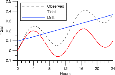
Tidal Correction
Gravity: It’s a natural phenomenon in which an invisible force pulls objects toward each other. Earth’s gravity is what keeps us on the ground and what makes things fall. Any object that has mass also has gravity including planets, stars, galaxies, and even light.
Gravity method: The gravity method depends on the natural gravimetric field of the Earth and Newton’s law of gravity. This method may be applied for elevation correction, topography, tidal correction, latitude correction, instrumental drift correction and so on.
Tides: Tides are the rise and fall of sea levels caused by the combined effects of the gravitational forces exerted by the Moon and the Sun and rotation of the Earth. Tide tables are used by locals to find the predicted times and amplitude.In1920, an engineer by name of ‘Dexter Cooper’ came up the idea of creating power of tides. There are four types of tides. They are:
- Diurnal tide: It’s a cycle which experience one high tide and one low tide in every lunar day.
- Semi diurnal tide: It’s a cycle which experience two high tide and two low tide in every lunar day.
- Mixed tide: It has two high tide and two low tide per day but height of each tide is different.
- Meteorological tide: It represent all atmospherically influenced tides such as storm surges.

Tidal correction Formula:
A correction made in gravity observations to remove the effect of the Earth’s tides. It has smaller mass, the gravitational attraction of the Moon is larger than that of the Sun because of it’s proximity. Actually, the periodic gravity variations caused by the combined effects of the Sun and the Moon are known as tidal variations.
The lunar tidal acceleration at the Earth’s surface along the Moon-Earth axis is about 1.110-2 g, the solar tidal acceleration at the Earth’s surface along the Sun-Earth axis is about 0.52
10-7 g where g is the gravitational acceleration at the Earth’s surface. The formula of the ‘Tidal Force’ is
F=GmMR-2
There are three types of tidal force. They are:
- The effects of Centrifugal Force.
- The effects of Gravitational Force.
- The Net or Differential Tide –Raising Force.
Importance of tides:
- It create the oceanic tide of the Earth’s oceans.
- It improve the accuracy of satellite which used in coastal areas.
- It’s mainly affect marine ecosystem.
- It influence the kinds of plants and animals that thrive in what is known as the intertidal zone.
- The area between high tide and low tide, many shorelines, tided from tide pools.
- It’s not only destroy but also help in the formation of creeks and inlets.
- In coastal area, locals trap water during high tides which is used for the manufacturing of salt.
- It helps fisherman and local people by navigation, recreation and coastal development.
Tidal correction measuring devices
Tidal corrections are crucial for various marine and geophysical applications, and there are several devices used to measure the tides and account for their influence. Here’s a breakdown of some common methods:
1. Tide Gauge:
- Description: This is a traditional and highly accurate method for measuring water level fluctuations due to tides.
- Functioning: There are two main types:
- Stilling Well Tide Gauge: A float inside a well connected to the open water measures the water level. The well dampens wave action, providing a more accurate reading of the tidal elevation.
- Pressure Sensor Tide Gauge: A submerged pressure sensor measures the pressure exerted by the water column, which translates to water level.
- Data Recording: Modern tide gauges record data electronically at regular intervals, providing a continuous record of water level variations.
- Applications: Tide gauges are used for:
- Establishing long-term tidal datums (reference water levels)
- Providing real-time data for tide prediction models
- Calibrating other tidal measurement methods
2. Acoustic Doppler Current Profiler (ADCP):
- Description: This instrument uses the Doppler effect to measure water velocity at different depths.
- Functioning: An ADCP transmits acoustic pulses and measures the shift in frequency of the reflected signal from moving particles in the water. By calculating this shift, the ADCP determines the water velocity at various depths.
- Tidal Correction: While not a direct measurement of water level, ADCP data can be used to estimate tidal currents and model their impact on other measurements (e.g., sound speed variations in sonar applications).
- Applications: ADCPs are commonly used in oceanography for:
- Studying ocean currents
- Measuring wave characteristics
- Collecting data for underwater navigation and positioning
3. GNSS (Global Navigation Satellite System) Buoys:
- Description: These are buoys equipped with GNSS receivers (like GPS) that continuously measure their position.
- Functioning: By recording precise changes in position, GNSS buoys can be used to calculate the rise and fall of the water level they are floating on, providing a measure of the tide.
- Applications: GNSS buoys are used for:
- Monitoring real-time water levels in remote locations
- Providing data for coastal flooding warnings
- Studying storm surge effects
4. Satellite Altimetry:
- Description: This method uses radar altimeters onboard satellites to measure the distance between the satellite and the ocean surface.
- Functioning: By subtracting the average ocean surface height (determined from models), satellite altimetry provides a global picture of sea level variations, including tidal effects.
- Applications: Satellite altimetry is used for:
- Monitoring global sea level rise
- Studying ocean circulation patterns
- Providing data for weather forecasting models
The choice of tidal correction measuring device depends on the specific application, desired accuracy, and real-time vs. long-term data collection needs.