Cyclone Mocha; 10 Alarming Issues of Sever Cyclone
Cyclone Mocha Rapidly Intensifies Ahead of Devastating Landfall in Myanmar and Bangladesh
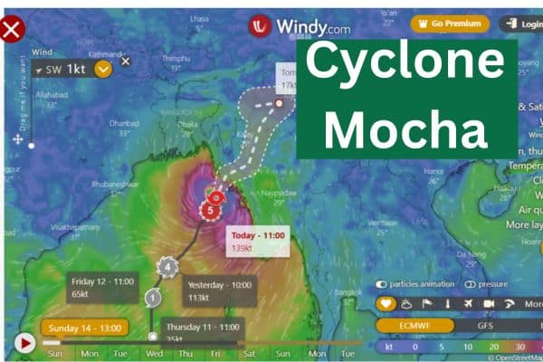
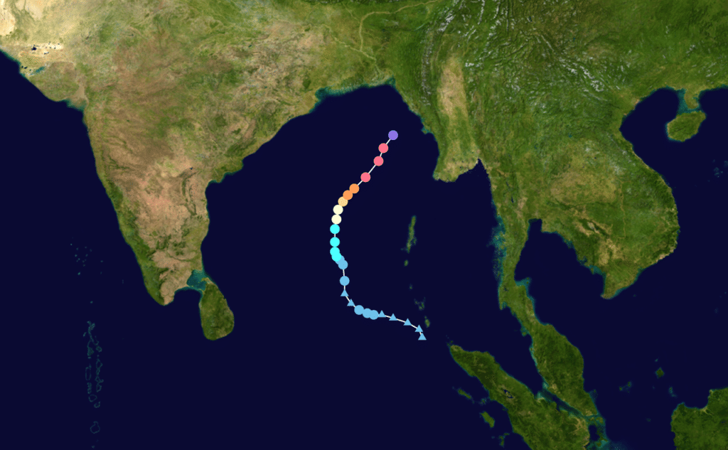
Brief Description: Cyclone Mocha, an extremely severe cyclonic storm, has rapidly intensified and is approaching the coast of Myanmar and Bangladesh. With sustained winds of around 150 mph, it is equivalent to a strong Category 4 hurricane. The cyclone is expected to make landfall near or north of Sittwe, Myanmar, with devastating impacts including destructive winds, storm surge, and heavy rainfall.
Evacuations are underway, but concerns remain due to the region’s low-lying topography and ongoing conflict in Myanmar. The storm is anticipated to be the strongest to hit Myanmar since Cyclone Nargis in 2008, and its effects may extend into parts of India and Tibet.
Cyclone Mocha, an extremely severe cyclonic storm rapidly intensifying before its landfall in Myanmar and Bangladesh, presents several alarming issues.

Here are ten key concerns associated with this severe cyclone mocha :
- Rapid Intensification: Cyclone Mocha has undergone rapid intensification, reaching near Category 5 strength, with sustained winds of approximately 150 mph with a max of 260 mph.
- Devastating Landfall: The cyclone is expected to make landfall near or north of Sittwe, Myanmar, potentially causing extensive damage and destruction.
- Destructive Winds: Mocha’s powerful winds, exceeding 150 mph, can lead to the destruction of structures, uprooted trees, and significant damage to infrastructure.
- Intense Storm Surge: The storm surge accompanying Mocha could reach heights of 6.5 to 13 feet (2 to 4 meters) above normal water levels, posing a severe threat to coastal areas.
- Heavy Rainfall: The cyclone is forecasted to bring widespread and intense rainfall, with a large swath of at least 5 to 10 inches (12 to 25 centimeters) expected along the northern Myanmar coastal region and into Bangladesh.
- Flooding Risk: The combination of storm surge and heavy rainfall increases the risk of widespread flooding, posing dangers to both coastal and inland areas.
- Threat to Human Lives: The cyclone’s landfall coincides with densely populated areas, including regions with large displaced populations and ongoing conflicts, potentially putting hundreds of thousands of lives at risk.
- Environmental Impact: Cyclone Mocha may cause severe damage to ecosystems, including coastal habitats, and contribute to long-term environmental consequences.
- Humanitarian Crisis: The cyclone’s impact on already vulnerable communities, coupled with the potential destruction of infrastructure and displacement of populations, may exacerbate the ongoing humanitarian crisis in the region.
- Historical Significance: If Mocha reaches its anticipated strength, it could become the strongest storm to hit Myanmar since Cyclone Nargis in 2008, which resulted in a devastating loss of life.
As Cyclone Mocha continues to intensify and approach land, authorities, and communities are taking precautionary measures to mitigate the impact of this severe cyclone.
Here is a general overview of how Cyclone Mocha may have formed:
- Atmospheric Conditions: The presence of a disturbance in the atmosphere, such as a low-pressure area or an atmospheric wave, provides the initial trigger for cyclone formation. In the case of Cyclone Mocha, there might have been an atmospheric disturbance near the region.
- Warm Ocean Waters: Cyclones thrive on warm ocean waters as a primary source of energy. The Bay of Bengal, where Cyclone Mocha formed, generally experiences high sea surface temperatures, providing ample heat and moisture for cyclone development.
- Low Wind Shear: Wind shear refers to the variation in wind speed or direction with altitude. Cyclones require low wind shear conditions, as high wind shear can disrupt their formation or weaken them. If wind shear is low or favorable, it allows the cyclone’s structure to organize and intensify.
- Intensification: As the atmospheric disturbance encounters warm ocean waters and encounters favorable wind conditions, it begins to intensify. Warm air near the ocean surface rises, creating an area of low pressure. The low-pressure area draws in more warm, moist air from the surrounding region, leading to further intensification.
- Eyewall Formation: As the cyclone intensifies, an eyewall develops. The eyewall is a ring of intense thunderstorms surrounding the central eye of the cyclone. It is characterized by the strongest winds and heaviest rainfall within the system.
- Further Development: If the cyclone continues to encounter favorable conditions, such as warm ocean temperatures and low wind shear, it can undergo rapid intensification. This process involves a significant increase in wind speeds and a more organized structure.
cyclone mocha update;
Windy.com
Cyclone mocha date; 8 May 2023 Started.
Cyclone mocha meaning;
Cyclone Mocha’s name was suggested by Yemen, and it originates from the Yemeni city Mocha (or Mokha) located on the Red Sea coast.


