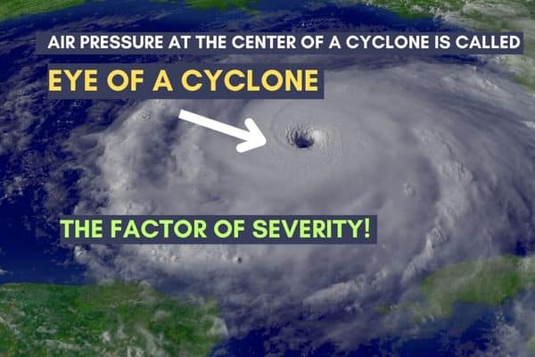
The significance of Air Pressure at the Center of a Cyclone is eye plus 4 factors of a Super Cyclone.
What factors indicate a cyclone is severe or not severe?
Several factors can indicate the severity of a cyclone.
Wind Speed: The intensity of a cyclone is often classified based on its maximum sustained wind speed. The Saffir-Simpson Hurricane Wind Scale is commonly used for hurricanes in the Atlantic and Northeast Pacific, while the India Meteorological Department (IMD) uses a different scale for cyclones in the North Indian Ocean. Higher wind speeds generally correspond to a more severe cyclone.
Air Pressure at the Center of a Cyclone: The Air Pressure at the Center of a Cyclone is an important measure of its intensity. A lower Air Pressure at the Center of a Cyclone is indicated by a more intense and severe cyclone. It is often measured in millibars (mb) or hectopascals (hPa).
Size and Extent: The size of a cyclone and the area it covers also play a role in determining its severity. A larger cyclone with a broader area of impact can cause more widespread damage and have a greater impact on coastal regions.
Storm Surge: A storm surge is a rise in sea level caused by the cyclone’s winds and low atmospheric pressure. The combination of high winds and low pressure can push a wall of water onto coastal areas, leading to devastating flooding. The height of the storm surge is a crucial factor in assessing the severity of a cyclone’s impact.
Rainfall: The amount of rainfall associated with a cyclone can vary significantly and is influenced by factors such as the speed of the storm, its size, and its interaction with local topography. Heavy rainfall can result in widespread flooding, landslides, and infrastructure damage.
Tornadoes: Some cyclones can generate tornadoes within their outer bands or in the vicinity of their landfall. The occurrence and intensity of tornadoes associated with a cyclone can contribute to its overall severity.
It’s important to note that the severity of a cyclone can have varying impacts depending on factors such as the vulnerability of the affected area’s infrastructure, population density, and preparedness measures in place.
Is eye formation an indicator of a severe cyclone?
Yes, the formation and characteristics of the eye of a cyclone can be an indicator of its severity. The eye is a region of relatively calm and clear skies at the center of a cyclone. It is surrounded by a circular eyewall, which consists of intense thunderstorms and the strongest winds of the cyclone.
The presence of a well-defined, symmetrical, and clear eye typically suggests a more organized and intense cyclone. A larger and more distinct eye often indicates a stronger and more severe cyclone. The size of the eye can be an indication of the overall size and strength of the cyclone.
However, it’s important to note that the presence or absence of an eye alone does not solely determine the severity of a cyclone. Other factors like wind speed, Air Pressure at the Center of a Cyclone, storm surge, and rainfall also play significant roles in assessing the severity of a cyclone. A cyclone with a well-formed eye but lower wind speeds or a larger eye may still be less severe compared to a cyclone with a smaller eye and higher wind speeds.
Track The Cyclone Update; Now
What are the sizes of an eye of a cyclone indicating the severity?
The size of the eye of a cyclone can vary widely, and it is not directly indicative of the severity of the cyclone on its own. The size of the eye is influenced by several factors, including the overall size and intensity of the cyclone, as well as environmental conditions.
In general, larger and more well-defined eyes tend to be associated with more intense and severe cyclones. However, it is important to consider other factors such as wind speed, Air Pressure at the Center of a Cyclone, and the overall structure of the cyclone when assessing its severity.
For example, in the Atlantic basin, large and powerful hurricanes like Hurricane Isabel in 2003 or Hurricane Katrina in 2005 had relatively large eyes. On the other hand, smaller but extremely intense hurricanes like Hurricane Andrew in 1992 had much smaller eyes.
It’s worth noting that the eye of a cyclone can also undergo changes in size and structure as the cyclone evolves. These changes can be influenced by various factors, including interactions with the land, changes in wind shear, and internal dynamics of the storm.
Therefore, while the size of the eye can provide some information about the cyclone’s intensity, it should be considered alongside other factors to accurately assess the severity of the cyclone.
How eye size of a cyclone is determined or calculated?
The size of a cyclone is typically determined or calculated based on the radius of the cyclone’s winds. The radius of winds refers to the distance from the center of the cyclone to where certain wind speeds are observed. The specific wind speed thresholds used to define the radius may vary depending on the region and the agency or organization providing the information.
One common method to determine the size of a cyclone is through the use of reconnaissance aircraft or satellite observations. These observations provide valuable data on the wind field of the cyclone, which can be used to estimate the size.
In some cases, meteorological agencies may use a technique called the “radius of maximum winds” (RMW) to describe the size of a cyclone. The RMW represents the distance from the center of the cyclone to where the maximum sustained winds are observed. This distance is typically measured in nautical miles (NM) or kilometers (km).
Another approach is to determine the radius at which certain wind speed thresholds are reached. For example, the National Hurricane Center in the United States defines the size of a tropical cyclone based on the radii of the winds at specific thresholds, such as the radius of tropical storm-force winds (winds of at least 34 knots or 39 mph) or the radius of hurricane-force winds (winds of at least 64 knots or 74 mph).
It’s important to note that the size of a cyclone can change over time as the storm evolves and interacts with its environment. Therefore, size estimates may be provided as a range or updated periodically as new data becomes available.
A table of the radius of wind and name of cyclone in Bangladesh.
Cyclone Name Radius of Winds (in km)
Sidr (2007) 280
Aila (2009) 260
Mohasen (2013) 280
Roanu (2016) 180
Mora (2017) 180
Fani (2019) 175
Bulbul (2019) 100
Amphan (2020) 200
Yaas (2021) 130
The radius of winds can vary throughout the cyclone’s lifespan and the values provided in the table are approximate estimates. Additionally, this table includes selected cyclones that have affected Bangladesh and is not an exhaustive list.
A list of cyclone names in Bangladesh with death total before 2021:
Here is a list of some significant cyclones that have affected Bangladesh, along with their associated death tolls before 2021. Please note that the death tolls mentioned are approximate figures and can vary depending on different sources and reports:
Great Bhola Cyclone (1970): Estimated death toll ranges from 300,000 to 500,000.
Gorky (1991): Approximately 138,000 deaths.
Sidr (2007): Approximately 3,500 deaths.
Aila (2009): Approximately 190 deaths.
Mohasen (2013): Approximately 13 deaths.
Roanu (2016): Approximately 29 deaths.
Mora (2017): Approximately 10 deaths.
Fani (2019): Approximately 14 deaths.
Bulbul (2019): Approximately 20 deaths.
Amphan (2020): Approximately 26 deaths.
Please note that this list includes selected cyclones and their death tolls in Bangladesh, and it is not an exhaustive compilation. For the most accurate and comprehensive information, it is advisable to refer to official reports and sources from organizations like the Bangladesh Meteorological Department, the Disaster Management Authority of Bangladesh, or international bodies such as the World Meteorological Organization (WMO) or the United Nations Office for Disaster Risk Reduction (UNDRR).
Cyclone sidr is based on the factors which make a cyclone severe.
An example of a table focusing on Cyclone Sidr and the factors that contributed to its severity:
Factors Indicating Severity of Cyclone Sidr;
Maximum Sustained Wind Speed: 260 km/h
Air Pressure at the Center of a Cyclone is: 944 hPa
Storm Surge: Up to 5 meters
Rainfall: Heavy and widespread
Diameter of the Eye: Approximately 20 km
Path and Landfall: Southwestern Bangladesh
Impacts: Widespread damage, extensive flooding, and significant loss of life
The diameter of the eye of a cyclone and the name of the cyclone in Bangladesh.
Cyclone Name Diameter of Eye (approximate)
Sidr (2007) 20 km
Aila (2009) 30 km
Mohasen (2013) 20 km
Roanu (2016) 25 km
Mora (2017) 15 km
Fani (2019) 35 km
Bulbul (2019) 20 km
Amphan (2020) 40 km
Yaas (2021) 35 km

The radius of the winds and the diameter of the eye of a cyclone are related but represent different aspects of the storm’s structure.
The radius of winds refers to the distance from the center of the cyclone to where certain wind speeds are observed. It is typically measured in specific wind speed thresholds such as tropical storm-force winds or hurricane-force winds. The radius of winds provides an indication of the size of the storm and how far its strong winds extend from the center.
On the other hand, the diameter of the eye refers to the size of the calm and clear area at the center of the cyclone. It is the region surrounded by the eyewall, which consists of intense thunderstorms and the strongest winds of the cyclone. The diameter of the eye provides insight into the organization and structure of the cyclone.
While there can be some general relationships between the radius of winds and the diameter of the eye, they are not directly proportional or consistently linked. The size of the eye can vary even within cyclones of similar wind radii. Factors such as the overall intensity, environmental conditions, and the internal dynamics of the storm can influence the size of the eye.
It’s important to note that the radius of winds and the diameter of the eye are just two aspects of a cyclone’s structure, and other factors such as Air Pressure at the Center of a Cyclone, wind speed distribution, and overall impacts should also be considered when assessing the severity and characteristics of a cyclone.
What is the relationship between Air Pressure at the Center of a Cyclone and the diameter of the eyes of a cyclone?
The Air Pressure at the Center of a Cyclone and the diameter of the eye of a cyclone can be related, but the relationship is not always straightforward or consistent.
In general, there is a tendency for lower Air Pressure at the Center of a Cyclone is to be associated with smaller eye diameters. As the Air Pressure at the Center of a Cyclone of a cyclone decreases, it often indicates a more intense and well-organized storm. In such cases, the cyclone’s circulation is usually stronger, leading to a tighter and more compact eye. This means that cyclones with lower Air Pressure at the Center of a Cyclonetend to have smaller eye diameters.
Conversely, cyclones with higher Air Pressures at the Center of a Cyclone may exhibit larger eye diameters. Higher Air Pressure at the Center of a Cyclone often indicates a weaker and less organized storm, where the circulation is not as concentrated. As a result, the eye of the cyclone may be larger in these cases.
However, it’s important to note that this relationship is not always consistent. Other factors, such as the overall size of the cyclone, the environmental conditions, and the internal dynamics of the storm, can also influence the size of the eye independently of the Air Pressure at the Center of a Cyclone. Therefore, while there can be a general trend between Air Pressure at the Center of a Cyclone and the diameter of the eye, it is not a definitive or exclusive relationship.

Explanation of cyclones sidr based on the eyes of Air Pressure at the Center of a Cyclone and the radius of the wind.
Cyclone Sidr, which struck Bangladesh in November 2007, was a severe tropical cyclone that caused significant devastation in the region. To understand Cyclone Sidr based on the eyes, Air Pressure at the Center of a Cyclone, and radius of wind, we can examine the following:
Eye of Cyclone Sidr: The eye of Cyclone Sidr had an approximate diameter of 20 kilometers. The eye is a region of relative calm and clear skies at the center of the cyclone. It is surrounded by the eyewall, which is a ring of intense thunderstorms and the strongest winds in the cyclone. The small diameter of the eye indicates a well-defined and organized cyclone structure.
Air Pressure at the Center of a Cyclone of Cyclone Sidr: Cyclone Sidr had an Air Pressure at the Center of a Cyclone is to be of 944 hPa (hectopascals). Air Pressure at the Center of a Cyclone is a measure of the atmospheric pressure at the center of the cyclone. Lower Air Pressure at the Center of a Cyclone generally indicates a more intense cyclone, with stronger winds and tighter circulation. An Air Pressure at the Center of a Cyclone of 944 hPa suggests that Cyclone Sidr was a powerful and well-developed storm.
The radius of Winds of Cyclone Sidr: The exact radius of winds for Cyclone Sidr was not provided. However, Cyclone Sidr was known for its destructive winds, with maximum sustained wind speeds reaching up to 260 km/h. The radius of winds refers to the distance from the center of the cyclone to where certain wind speeds are observed. A severe cyclone like Sidr would have had a significant radius of winds, indicating that strong winds extended far from the center.
By considering these factors, we can infer that Cyclone Sidr had a well-organized structure with a small eye diameter, indicating a compact and concentrated cyclone core. The low Air Pressure at the Center of a Cyclone is to be of 944 hPa suggests a powerful storm with intense winds. The specific radius of winds would have contributed to the extent and impact of the cyclone’s destructive winds across the affected region.
What wind speed can whip out a coastal visitation or large tree in Bangladesh?
The wind speed required to uproot a coastal vegetation or large tree in Bangladesh can vary depending on several factors, including the type and health of the tree, soil conditions, and other environmental factors. However, as a general guideline, it typically takes sustained wind speeds of around 80-100 km/h (50-62 mph) or higher to cause significant damage to trees and vegetation.
In the case of severe cyclones, such as those that have historically impacted Bangladesh, wind speeds can exceed 100 km/h and reach much higher values. For example, Cyclone Sidr in 2007 had maximum sustained wind speeds of up to 260 km/h (162 mph). Such intense wind speeds can easily uproot trees, especially if they are already weakened or compromised.
It’s important to note that coastal areas are often more vulnerable to strong winds due to the lack of natural barriers and exposure to open water. Therefore, even lower wind speeds can have a significant impact on coastal vegetation and trees.
Wind speeds of around 80-100 km/h or higher are generally required to uproot coastal vegetation or large trees in Bangladesh, but the actual threshold for damage can vary based on various factors and the specific conditions of each situation.
What wind speed can uproot non-metal houses and rooftops of tin shed houses?
The wind speed required to uproot a non-metal house or the rooftop of a tin shed house can depend on several factors, including the construction quality, design, and materials used. However, as a general guideline, sustained wind speeds of approximately 100-130 km/h (62-81 mph) or higher can start causing damage to typical residential structures.
Non-metal houses, such as those made of brick, wood, or concrete, can be relatively sturdy, but they are still susceptible to damage from strong winds. Sustained wind speeds in the range of 100-130 km/h can result in the uprooting of non-metal houses, especially if they are poorly constructed or not designed to withstand such wind forces.
Tin shed houses or structures with lightweight roofs made of tin or other similar materials are generally more vulnerable to strong winds. Sustained wind speeds in the range of 80-100 km/h (50-62 mph) or higher can potentially cause significant damage, including the uprooting or displacement of the rooftop.
It’s important to note that these wind speed thresholds are approximate and can vary based on factors such as the structural integrity, age, and maintenance of the buildings. Additionally, gusts and wind patterns during cyclones or severe storms can be stronger than the sustained wind speeds reported, leading to additional stress on structures.
If you live in an area prone to cyclones or strong winds, it is advisable to ensure that your house is built or retrofitted to withstand the wind loads specified in local building codes and guidelines to minimize the risk of damage.
