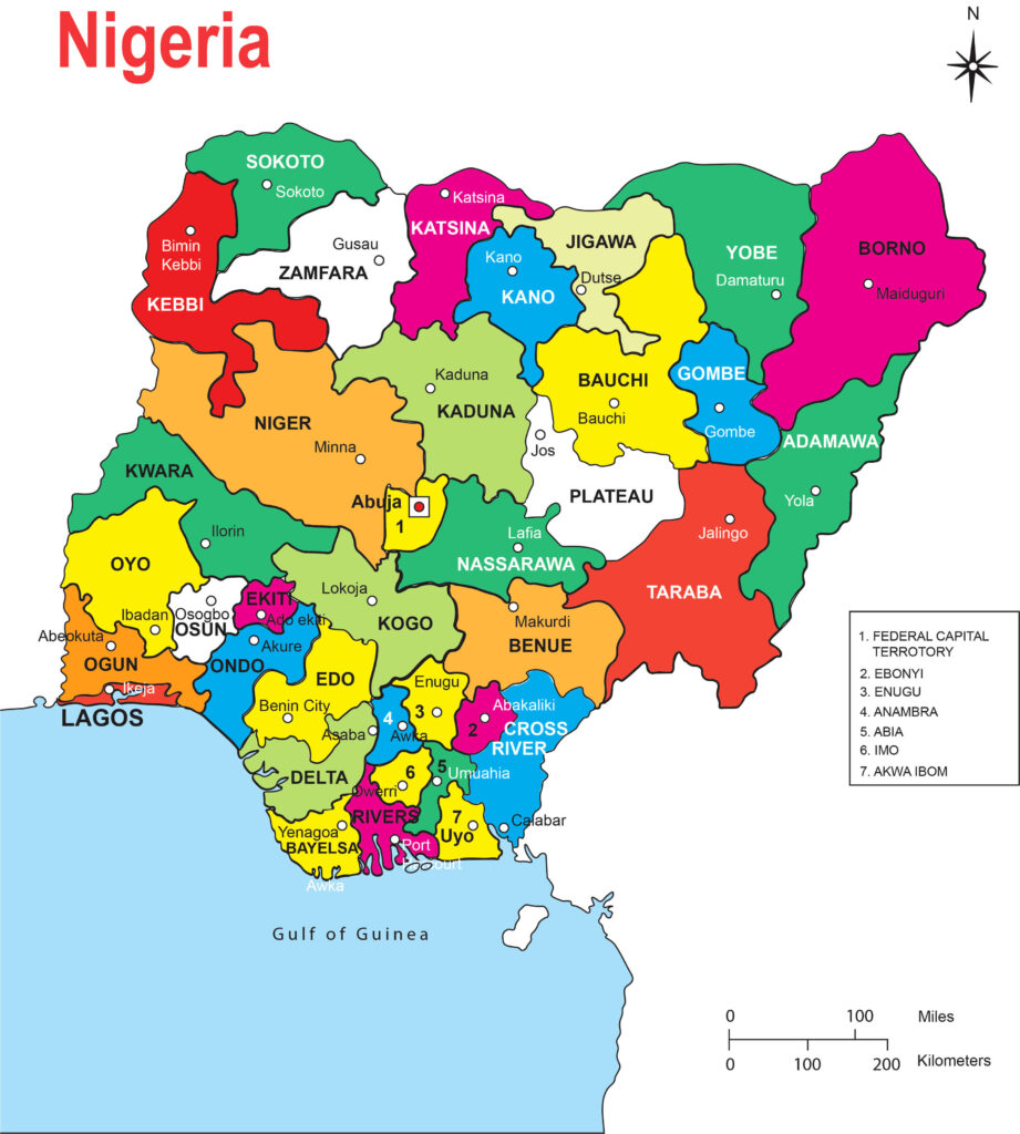
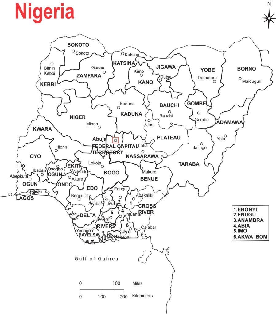
The map of Nigeria Lagos (Colored and free Download HD)
Lagos is a city located in the southwestern part of Nigeria, along the Gulf of Guinea. It is the largest city in Nigeria and one of the fastest-growing cities in the world. The city of Lagos is situated on the Lagos Lagoon, which connects to the Atlantic Ocean.
The map of Lagos shows a densely populated urban area with a mix of residential, commercial, and industrial zones. The city is known for its diverse neighborhoods, ranging from affluent areas with luxurious houses and modern infrastructure to more informal settlements and slums. The central business district, known as Lagos Island, is a hub of economic activity, with numerous skyscrapers, government buildings, and corporate offices.
Lagos is connected by a network of roads and bridges that span across various water bodies, including the Third Mainland Bridge, Eko Bridge, and Carter Bridge. These bridges are essential for commuting and transportation within the city.
The map also features significant landmarks and points of interest in Lagos, such as the National Museum, Tafawa Balewa Square, Lagos Island Market (Idumota), Lekki Conservation Centre, and the University of Lagos. Additionally, you may find various parks, recreational areas, and cultural centers throughout the city.
Lagos is served by the Murtala Muhammed International Airport, located in the northern part of the city, which connects it to domestic and international destinations.
How many states are in Nigeria?
There are 36 states in Nigeria, plus the Federal Capital Territory (FCT) which houses the capital city, Abuja. Therefore, the map of Nigeria would typically include 36 states and the Federal Capital Territory. Each state has its own administrative structure and is further divided into local government areas.
It’s worth noting that Nigeria’s administrative divisions are subject to change over time as new states or local government areas may be created or existing ones may be modified. For the most up-to-date information, it is advisable to refer to recent sources or official government websites.
However, the capital of Nigeria is Abuja. It became the capital city of Nigeria on December 12, 1991, replacing Lagos. Abuja is located in the center of the country and serves as the administrative and political hub of Nigeria. It houses the Nigerian government offices, including the Presidential Complex, National Assembly, and Supreme Court. Additionally, Abuja is known for its modern infrastructure, planned layout, and several iconic landmarks, such as the Nigerian National Mosque and Nigerian National Christian Centre.
Background History of Logos.
The former capital of Nigeria, Lagos, holds a significant place in the country’s history and development. Lagos served as the capital city from Nigeria’s independence in 1960 until December 12, 1991, when the capital was officially relocated to Abuja.
Lagos is located in the southwestern part of Nigeria and is situated along the Atlantic coastline. It is the most populous city in Nigeria and one of the largest cities in Africa. With its strategic location, Lagos has historically been a center of trade, commerce, and cultural exchange.
During its time as the capital, Lagos experienced significant growth and development. It became a bustling metropolis and an economic powerhouse, attracting businesses, industries, and multinational corporations. The city played a crucial role in Nigeria’s political, economic, and cultural spheres.
Lagos was known for its vibrant and diverse neighborhoods. The central business district of Lagos Island housed the commercial heart of the city, with its tall buildings, banks, corporate headquarters, and markets. The island also featured historic sites like Tafawa Balewa Square, which served as a venue for important events and public gatherings.
Lagos was renowned for its energetic and dynamic atmosphere. It had a thriving arts and entertainment scene, with theaters, art galleries, music venues, and a vibrant nightlife. The city was also home to prestigious educational institutions, including the University of Lagos, which contributed to its intellectual and academic prowess.
However, as Lagos grew rapidly, it also faced numerous challenges. Overpopulation, traffic congestion, inadequate infrastructure, and housing shortages were some of the issues that emerged. The decision to move the capital to Abuja was driven by the need for a more centrally located administrative hub that could accommodate future growth and address the challenges faced by Lagos.
Although Lagos is no longer the capital, it remains an essential and influential city in Nigeria. It continues to be a major economic center, with a diverse range of industries, including finance, telecommunications, media, and entertainment. Lagos retains its vibrant culture, with a rich heritage reflected in its cuisine, music, festivals, and arts.
Today, Lagos serves as the commercial capital of Nigeria and a global city in its own right. It maintains its unique character, blending tradition and modernity, and remains an important cultural and economic hub in Africa.
The map of Nigeria Lagos (Colored and free Download HD)

The map of Nigeria Lagos (Colorless and free Download HD)

