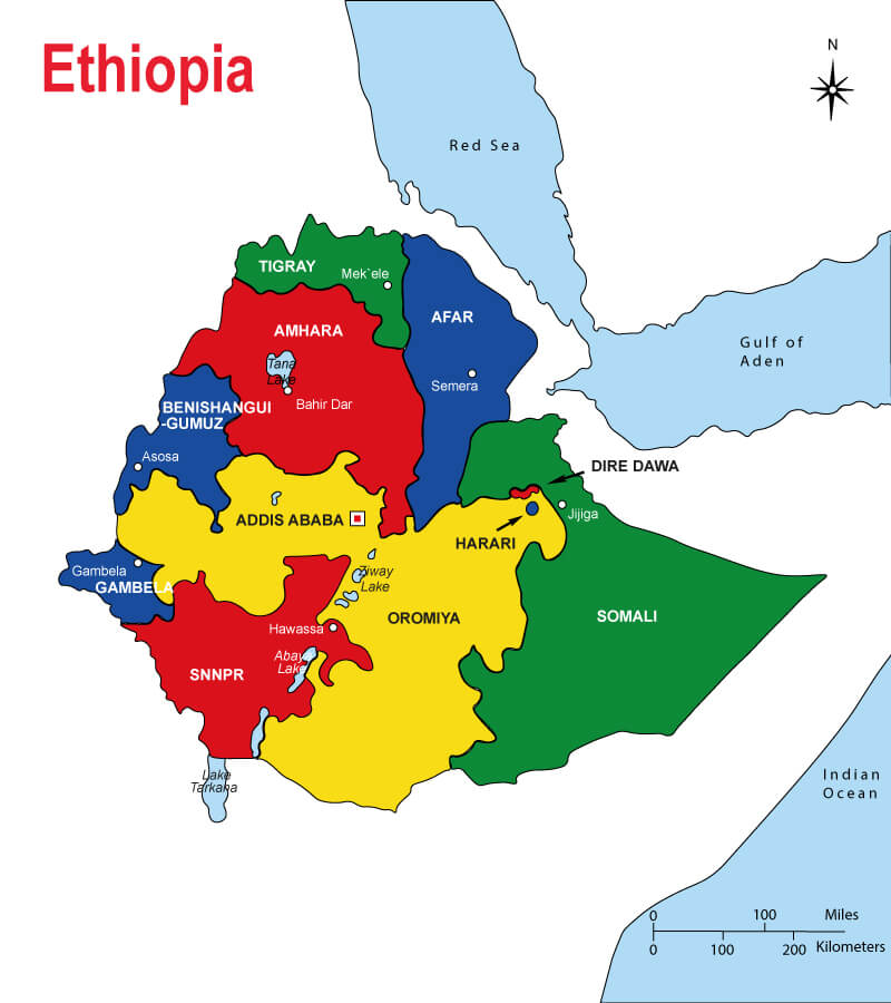
1 Map of Ethiopia HD Free Download Commercial USE
Exploring the Beauty of Ethiopia Through Its Maps
Ethiopia, a mesmerizing country located in the Horn of Africa, is a land of diverse landscapes, rich cultural heritage, and ancient history. If you’re eager to embark on a virtual journey through this remarkable nation, a map of Ethiopia will be your guiding compass. In this article, we will delve into the captivating aspects of Ethiopia’s geography, delve into the history behind its borders, and uncover the hidden gems that await adventurous souls. So, fasten your seatbelts as we begin our exploration!
Understanding Ethiopia’s Geographical Layout
Before diving into the intricate details of Ethiopia’s geography, let’s get an overview of its geographical layout. Situated in the northeastern part of Africa, Ethiopia shares borders with six countries: Eritrea to the north, Djibouti and Somalia to the east, Kenya to the south, and Sudan and South Sudan to the west. Spanning an area of approximately 1.1 million square kilometers, Ethiopia is the 27th largest country in the world. Its diverse topography encompasses highlands, lowlands, plateaus, and the mesmerizing Great Rift Valley.

The Highlands: Roof of Africa
The Ethiopian Highlands, also known as the Roof of Africa, dominate the northern and central parts of the country. This rugged mountainous region is a paradise for hikers, nature enthusiasts, and those seeking breathtaking views. The Simien Mountains, a UNESCO World Heritage Site, stand tall in this region, with Ras Dashen, the highest peak in Ethiopia, reaching an elevation of 4,550 meters.
The Great Rift Valley: A Geological Marvel
Moving towards the southern part of Ethiopia, we encounter the remarkable Great Rift Valley. Stretching over 6,000 kilometers from the Red Sea to Mozambique, this geological marvel is home to numerous lakes, rivers, and volcanic formations. Lake Abiyata, Lake Shala, and Lake Langano are among the stunning lakes nestled within the Rift Valley. These serene bodies of water offer a tranquil oasis and support a rich array of wildlife.
Borders and Boundaries: Historical Significance
To truly appreciate the significance of Ethiopia’s map, we must explore the historical context of its borders. Ethiopia’s current borders were established during the colonial era, as European powers partitioned Africa among themselves. The country managed to preserve its independence throughout this period, making it one of the few African nations that were never colonized. However, it did experience territorial disputes with neighboring countries, resulting in some border adjustments over time.
The Ongoing Quest for Accuracy
Mapping Ethiopia has been an ongoing endeavor, driven by the need for accuracy and the exploration of uncharted territories. Historically, cartographers faced challenges in accurately representing Ethiopia’s diverse landscapes, often leading to inconsistencies. However, advancements in technology, such as satellite imagery and Geographic Information Systems (GIS), have significantly improved the precision and detail of Ethiopia’s maps in recent years.
Navigating Ethiopia: Maps for Exploration
Whether you’re a history enthusiast, an adventure seeker, or a traveler planning your Ethiopian itinerary, maps play a vital role in guiding your exploration. Thanks to the internet and modern technology, maps of Ethiopia are readily accessible through various platforms. Online maps provide valuable information about cities, landmarks, roads, and points of interest, empowering travelers to navigate the country with ease.
In conclusion, a map of Ethiopia serves as a gateway to the country’s enchanting landscapes, rich history, and diverse cultural heritage. By studying and utilizing these maps, we can embark on captivating journeys through the highlands, witness the geological wonders of the Great Rift Valley, and gain insights into Ethiopia’s historical boundaries. So, whether you’re an armchair traveler or planning a real-life adventure, let the maps be your trusted companion as you explore the wonders of Ethiopia.
Here is a list of the nine regional states in Ethiopia:
- Tigray
- Afar
- Amhara
- Oromia
- Somali
- Benishangul-Gumuz
- Southern Nations, Nationalities, and Peoples’ Region (SNNPR)
- Gambela
- Harari

