Digital Map of Bangladesh of 1971 FREE PDF
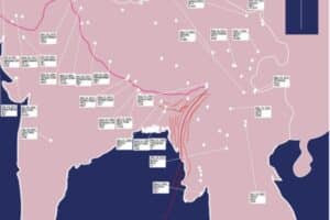
I was looking for the digital map of Bangladesh for many days but I have prepared it by myself using the illustrator cc. In this HD map, you will get the map of Asia Bangladesh during the liberation war in Pakistan and Bangladesh.
This is the map of Bangladesh and India because surrounding Bangladesh west Bengal, Tripura, and Meghalaya in India are located. I have added all the transportation developed in Bangladesh in 1971. Bangladesh had less than 64 districts then, among them, Magura, Meherpur, and Jhenida, are not districts like today (Districts of Bangladesh).
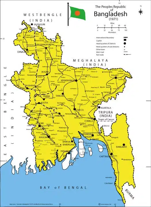
The Digital Map of Bangladesh (transportation) in 1971:
Download the Adobe Illustrator version (.ai) (.svg) of Digital Map of Bangladesh.ai This is the map of Bangladesh during the liberation war in 1971 showing the transportation route and the major districts and sub-divisions. During the liberation war in Bangladesh, there are not 64 districts in the east Pakisthan, recent Bangladesh. The major cities are
- Dacca
- Chittagong
- Khulna
- Rajshahi
- Sylhet
- Barisal
- Rangpur
- Mymensingh
- Comilla
- Narayanganj
- Gazipur
- Narsingdi
- Tongi
- Cox’s Bazar
- Jessore
- Faridpur and so on.
The transportation system in Bangladesh (See details in the Map included)
-
Roads:
-
Railways:
-
Waterways:
-
Airways:
-
Rickshaws:
Download more maps:
⇒ 1 Map of Ethiopia HD Free Download Commercial USE ⇒ Political Map of South Africa With 11 Major City ⇒ Map of Ghana Accra with 10 Major Cities in Africa ⇒ চাঁপাইনবাবগঞ্জ সদর উপজেলার map
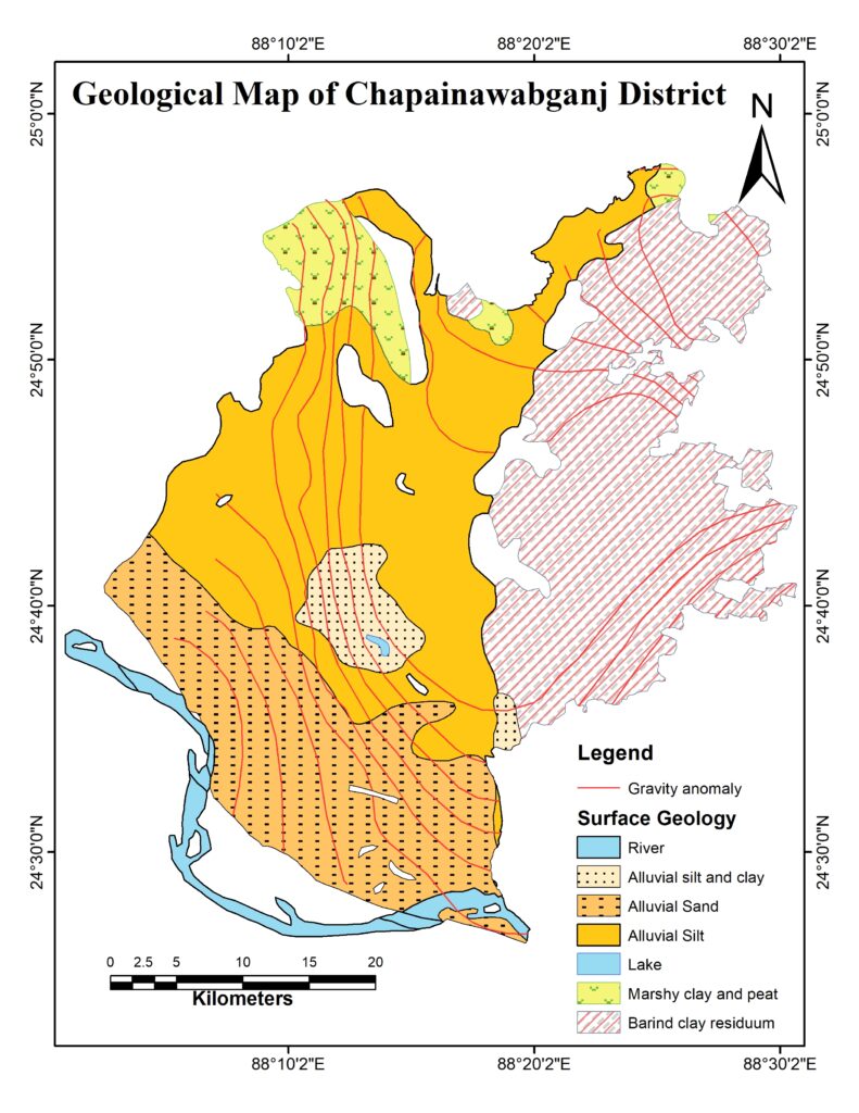
Geological Map of Chapainawabgonj district
We know that a geological map is a special-purpose map made to show various geological features such as rock types, Faults, Folds, etc. The provided geological map is produced by ArcGIS 10.5 software. As far as I am concerned this is the first attempt to create a geological map of the Chapainawabgonj district.
NB: If you require any further information, feel free to contact me for HD Map.
More Map of Bangladesh
⇒ Digital Map of Bangladesh of 1971 FREE PDF
⇒ চাঁপাইনবাবগঞ্জ সদর উপজেলার map
⇒ Geologic Map of Nawabganj-Rajshahi-Natore-Naogaon
More Map of the World
⇒ 1 Map of Ethiopia HD Free Download Commercial USE
⇒ Map of Ghana Accra with 10 Major Cities in Africa
Geologic map of Bangladesh:
Geologic maps basically show the distribution of several types of rock and surficial deposits, and the locations of geologic structures, for example, faults and folds.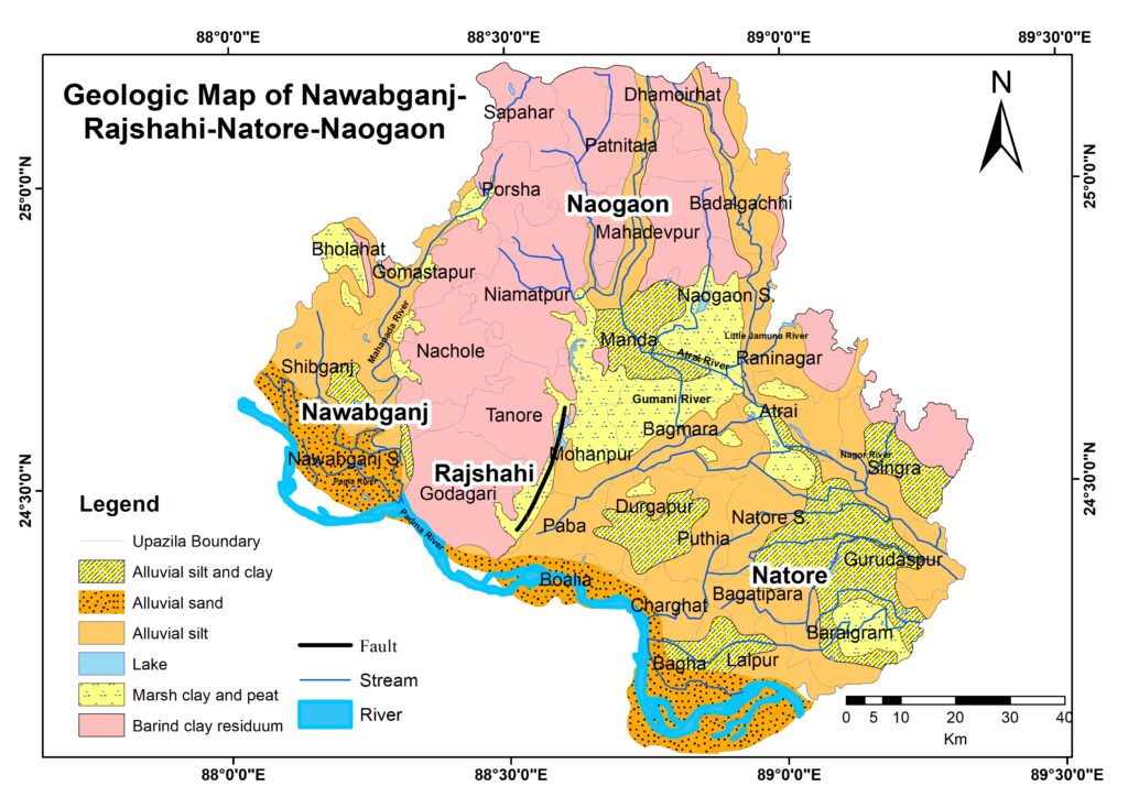
More Geologic Map of Bangladesh
⇒ চাঁপাইনবাবগঞ্জ সদর উপজেলার map ⇒ Geological Map of Chapainawabgonj districtDigital Map of Bangladesh
⇒ Digital Map of Bangladesh of 1971 FREE PDFThe location map of Patuakhali Science and Technology University
The location map (LM) of Patuakhali Science and Technology University (PSTU) was developed using remote sensing techniques (Cartalinx and ArcGIS Software) on 19 July 2011 (1st Ed.) with proper approval and funding from the university authority of PSTU https://www.pstu.ac.bd The 1st edition was named the ‘Digital Map of PSTU’.The location map of Patuakhali Science and Technology University
Patuakhali Science and Technology University: Where Innovation Meets Excellence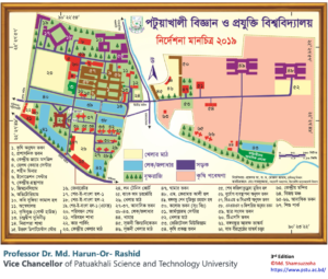
The Journey Begins
At Patuakhali Science and Technology University, our journey starts with a commitment to providing high-quality education in the fields of science and technology. Founded in [year of establishment], PSTU has consistently evolved to meet the dynamic demands of the modern educational landscape.Academic Excellence
PSTU has earned a reputation for academic excellence, and rightfully so. Our dedicated faculty members, state-of-the-art laboratories, and cutting-edge research facilities ensure that students receive a world-class education. Our programs cover a wide spectrum, from engineering to agriculture, creating well-rounded graduates ready to take on the challenges of the real world.Innovation and Research
Innovation is the lifeblood of PSTU. Our university encourages a culture of innovation and research. We believe that true learning comes from not just studying textbooks but also exploring the uncharted territories of knowledge. Our research centers and projects have made significant contributions to various fields, making PSTU a name to reckon with in the academic world. Life at PSTU is not just about academics. Our vibrant campus is a melting pot of cultures, ideas, and experiences. We believe in holistic development, and that’s why we offer a wide range of extracurricular activities. Whether it’s sports, clubs, or cultural events, there’s something for everyone at PSTU.Community Engagement
At PSTU, we believe in giving back to the community. We actively engage in outreach programs, helping local communities through various initiatives. This not only enriches the lives of our students but also creates a positive impact on society.Alumni Success Stories
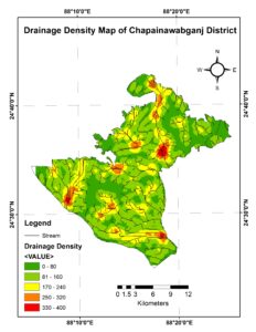
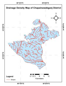
Our success can be measured by the achievements of our alumni. Graduates of PSTU have gone on to make their mark in various industries around the world. From renowned scientists to successful entrepreneurs, our alumni embody the spirit of excellence instilled in them during their time at PSTU.চাঁপাইনবাবগঞ্জ জেলার Drainage Density এবং Stream Order ম্যাপ ড্রেনেজ ডেসনেসিটি ম্যাপ
কিভাবে চ্যানেলগুলি বিভিন্নভাবে নিষ্কাশন করা হয় তার চিত্র নির্দেশ করে (চিত্র 1 এবং চিত্র 2)। উচ্চ ঘনত্ব মান সাধারণত বন্যার ঝুঁকি পূর্ণ এলাকা নির্দেশ করে।- Watershed হ’ল জমির একটি অঞ্চল যা জলের জলের বহিঃপ্রবাহ, একটি উপসাগরের মুখ বা কোনও স্ট্রিম চ্যানেলের পাশাপাশি যে কোনও বিন্দুতে একটি সাধারণ আউটলেটে সমস্ত স্রোত এবং বৃষ্টিপাতকে সরিয়ে দেয়।
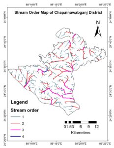
স্ট্রিম অর্ডার (Stream Order)
- স্ট্রিম অর্ডার ম্যাপ স্ট্রিম অর্ডার তাদের শাখার সংখ্যার উপর ভিত্তি করে স্ট্রিমের প্রকারগুলি সনাক্ত এবং শ্রেণিবদ্ধ করার জন্য একটি পদ্ধতি (চিত্র 3)
- উদাহরণস্বরূপ: প্রথম অর্ডার স্রোতগুলি পানির ওভারল্যান্ড প্রবাহের দ্বারা প্রাধান্য পায়; তাদের কোনও প্রবাহিত ঘন প্রবাহ নেই।
- আপনার যদি আরও কোনও তথ্য প্রয়োজন হয় তবে দয়া করে নির্দ্বিধায় আমার সাথে যোগাযোগ করুন।
Geophysical Disaster of Bangladesh
Bangladesh is most vulnerable to several natural disasters and every year natural calamities upset people’s lives in some part of the country. The major disasters concerned here are the occurrences of flood, cyclones and storm surge, flash flood, drought, tornado, riverbank erosion, and landslide. These extreme natural events are termed disasters when they adversely affect the whole environment, including human beings, their shelters, or the resources essential for their livelihoods.| Types of Disaster | Areas Affected | Impact |
| Flood | Floodplains of the Brahmaputra-Jamuna, the Ganges-Padma and the Meghna river system | Loss of agricultural production, disruption of communication and livelihood system, injury, damage and destruction of immobile infrastructure, disruption to essential services, national economic loss, evacuation, and loss of human lives and biodiversity, displacement and sufferings of human population. |
| Cyclone and Storm Surge | Coastal areas and offshore islands | Loss of agricultural production, disruption of communication and livelihood system, damage and destruction of immobile infrastructure, injury, national economic loss, loss of biodiversity and human lives, need for evacuation and temporary shelter |
| Tornado | Scattered areas of the country | Loss of human life and biodiversity, injury, damage and destruction of property, damage of cash crops, disruption in lifestyle, damage to essential services, national economic loss and loss of livelihood. |
| Drought | Almost all areas, especially the Northwest region of the country | Loss of agricultural production, stress on national economy and disruption in life style. |
| Flash Flood | Haor Basins of the North-east region and South-eastern hilly areas | Damage of standing crops, disruption in life style, evacuation and destruction of properties. |
| Hail Storm and Lightning | Any part of the country | Damage and destruction of property, damage and destruction of subsistence and cash crops and loss of livelihood |
| Erosion | Banks of the Brahmaputra-Jamuna, the Ganges-Padma and the Meghna river systems | Loss of land, displacement of human population and livestock, disruption of production, evacuation and loss of property |
| Landslide | Chittagong and Chittagong Hill Tracts | Loss of land, displacement of human population and livestock, evacuation, damage of property and loss of life |
| Earthquake | Northern and central parts of the country | Damage and destruction of property, loss of life and change in geomorphology of land surface. |

PRESSURES
It has often been pointed out that the worst disasters in the world tend to occur between the Tropic of Cancer and the Tropic of Capricorn, which is coincidentally the area that contains the poorer countries (Carter, 1991).| Issue | Pressure/Cause | Impacts | Responses |
| Flood | · Excess flow in monsoon · Improper infrastructural development · 92 per cent of the total catchments area across the boarder · Drainage congestion due to river bed siltation | · Deforestation in upper catchment area · Disruption of communication and livelihood system · Loss of agricultural production · Disruption of essential services · National economic loss · Loss of human lives and biodiversity | · CDMP (Comprehensive Disaster Management Program) · FAP (Flood Action Plan) · National Water Policy · Flood forecast and inundation modeling · Dredging of river bed · Construction of embankments with sluice gates |
| Drought | · Less and uneven rainfall in dry season and wet season · Non-availability of surface water in dry season · Fluctuation of Ground Water table | · Loss of agricultural production · Stress on national economy due to bad harvesting · Disruption of life style · Reduction of fresh water fish production | · Agricultural research and extention works · Intensive Afforestation Program · Re-excavation of channels and ponds in rural areas · Augmentation of surface water flow · Construction of water reservoir |
| Cyclone & Storm surge | · Geographical setting of Bangladesh · Coastal configurations and bathymetry of the Bay of Bengal · Location of ITCZ near the equator and its shifting with the apparent movement of the sun across the Bay | · Disruption of communication and livelihood system · Damage and destruction of property · Environmental degradation · Loss of lives and agricultural production · National economic loss warning dissemination system | · CDMP (Comprehensive Disaster Management Program) · Strengthening of CPP (Cyclone Preparedness Program) · Local Disaster Action Plans for the grassroot levels along the coastal belt · Awareness building programs for the target group · Reliable and timely warning and effective |
| Tornado | · Intense ground heating and low level moisture incursion from the Bay of Bengal during pre and post monsoon · Conjugation of western disturbance with locally developed low pressure | · Loss of lives and biodiversity. · Destruction of property and damage of cash crops · Damage to essential services · National economic loss and loss of livelihood | · Proper radar network · Reliable and timely forecast capability for severe nor’wester · Awareness building programs · Quick search and rescue system |
| Earthquake | · Geographical location of Bangladesh having major and moderate faults | · Damage and destruction of property · Loss of lives and disruption of life style | · Proper implementation of Building code (1993) · Inventory of equipment for rescue operation |
ITCZ
The Intertropical Convergence Zone (ITCZ) is the area encircling the earth near the equator where winds originating in the northern and southern hemispheres come together. where the trade winds of the Northern and Southern Hemispheres come together. The intense sun and warm water of the equator heats the air in the ITCZ, raising its humidity and causing it to rise.Western Disturbance
Western Disturbance is the term used in India, Pakistan and Nepal to describe an extratropical storm originating in the Mediterranean, that brings sudden winter rain and snow to the northwestern parts of the Indian subcontinent. This is a non-monsoonal precipitation pattern driven by the Westerlies. The moisture in these storms usually originates over the Mediterranean Sea and the Atlantic Ocean.Contact:



More Stories
Map of Southwest USA
Palestine Vs Israel Supporter by Countries
Kenya Map Digital Map of Kenya EPS 794 KB