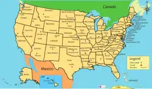
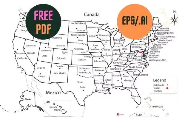
America Map: 3 Format JPEG-PDF-ai FREE
Exploring the America Map: A Journey Through Geography
If you’ve ever been curious about the vast and diverse landscapes of the Americas, you’re in the right place. In this article, we will embark on a captivating journey through the intricacies of the America Map. From the lush rainforests of South America to the Arctic tundra of North America, let’s dive deep into this geographical wonderland.
Download The Map USA HD FREE PDF
The Americas: A Continent of Diversity
Before we delve into the specifics of the America Map, it’s essential to understand the continent itself. The Americas, comprising North, Central, and South America, offer a breathtaking array of geographical features. From the towering Rocky Mountains to the Amazon River, each region has a unique story to tell.
North America: A Land of Contrasts
Starting our journey in North America, we find a land filled with contrasts. The continent’s largest country, the United States, stretches from the Atlantic to the Pacific, offering a varied landscape. The majestic Rockies run like a spine through the western part of the country, while the Great Plains provide vast, fertile lands for agriculture.
Heading north, we encounter Canada, a country known for its stunning natural beauty. The Canada Map showcases the vast wilderness of the northern regions, including the Canadian Rockies and the Arctic Archipelago. With its serene lakes and rugged terrain, Canada is a nature lover’s paradise.
Central America: The Bridge Between Continents
Nestled between North and South America, Central America acts as a bridge connecting these two continents. Its map reveals a chain of countries known for their rich cultural heritage and lush rainforests. From the ancient Mayan ruins in Mexico to the stunning beaches of Costa Rica, Central America offers a wealth of experiences for travelers.
South America: A Continent of Wonders
Moving further south, we arrive in South America, a continent teeming with natural wonders. The South America Map showcases the Amazon Rainforest, the world’s largest tropical rainforest, which is home to an astonishing array of wildlife. The Andes Mountains, stretching along the western edge of the continent, provide breathtaking vistas and opportunities for adventure.
Download The Map USA HD FREE in Illustration Version (.ai)
The Diversity of Cultures
The America Map is not just about geography; it’s also a reflection of the diverse cultures that inhabit this vast continent. From the Inuit communities in the Arctic to the indigenous tribes of the Amazon, each region has a unique cultural tapestry.
North America: A Melting Pot
North America is a true melting pot of cultures, shaped by centuries of immigration. The United States, in particular, is known for its cultural diversity, with people from all corners of the globe calling it home. From New York’s vibrant neighborhoods to the French influence in Louisiana, North America’s cultural map is as diverse as its landscapes.
Central America: Ancient Roots
In Central America, we find the remnants of ancient civilizations such as the Maya and the Aztec. Their architectural marvels, like Chichen Itza and Tikal, stand as a testament to their rich history. The cultural heritage of these indigenous communities is still very much alive in the traditions and customs of the region.
South America: Vibrant and Colorful
South America is a continent bursting with vibrant cultures. From the colorful festivals of Brazil’s Carnival to the mystical rituals of the Andean people, the continent’s cultural map is a kaleidoscope of traditions. The diverse cuisine, music, and dance of South America reflect the vitality of its people.
The America Map as a Tool
Beyond its beauty and cultural richness, the America Map serves practical purposes as well. It’s an indispensable tool for a wide range of applications.
Navigation and Exploration
For centuries, explorers like Christopher Columbus and Lewis and Clark relied on maps to navigate the uncharted territories of the Americas. Today, modern technology has made navigation more accessible than ever, with GPS systems that use maps to guide us to our destinations.
Environmental Conservation
The America Map plays a crucial role in environmental conservation. Conservationists use maps to track the spread of deforestation in the Amazon or the melting of glaciers in Alaska. By monitoring these changes, they can develop strategies to protect our planet’s precious resources.

Education and Research
In the realm of education and research, maps are invaluable tools. They help students and researchers understand the geography, demographics, and cultural distribution of the Americas. Geographic Information Systems (GIS) technology allows us to create interactive maps that aid in various fields, from urban planning to epidemiology.
The Future of the America Map
As we look ahead, the future of the America Map is exciting. With advances in technology, we can expect more detailed and interactive maps that provide real-time data. These maps will continue to be essential for addressing challenges like climate change, urbanization, and resource management.
In conclusion, the America Map is not just a piece of paper or a digital image; it’s a window into a continent teeming with diversity, culture, and opportunities. Whether you’re an adventurer exploring the rugged terrains of the Rockies or a researcher analyzing demographic trends, the America Map is your trusty companion. So, next time you look at a map of the Americas, remember that it’s not just lines and colors; it’s a gateway to a world of wonders.
Download More Maps
Bangladesh Map pdf 2 Format HD
Shailkupa Map: 14 Union FREE HD PDF Ai
Map of Indiana and Sattelite Image
Morocco Map Free HD PDF/ ai/ EPS
Africa map and satellite image: 5 Things to Explore
Map of USA and Mexico 5 Format Free PDF/ESP/ai/SVG
