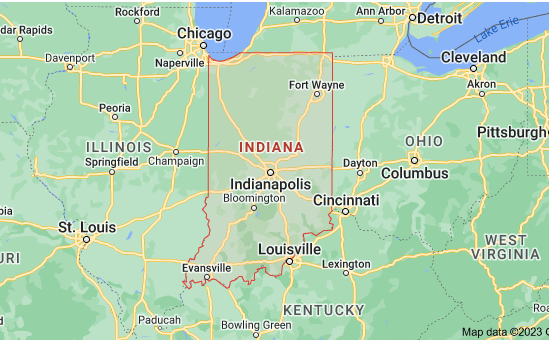
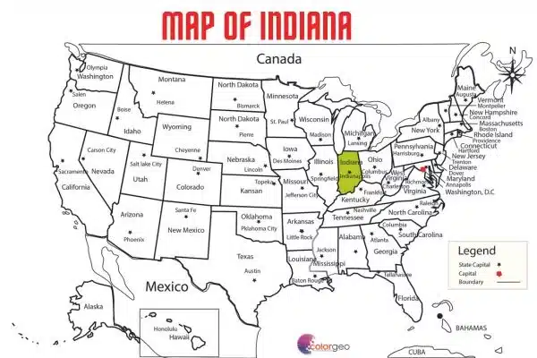
Map of Indiana and Sattelite Image
Exploring Indiana: A Comprehensive Guide to Maps
When it comes to exploring the vibrant state of Indiana, a map can be your best friend. Whether you’re planning a road trip, studying geography, or just curious about the Hoosier State, a well-detailed map of Indiana is an invaluable resource. In this article, we will dive deep into the world of Indiana maps, exploring their types, significance, and how they can enhance your adventures in this charming state.
The Basics of Indiana Geography
Before we delve into maps, let’s start with the basics. Indiana, located in the Midwest region of the United States, boasts diverse landscapes. It’s known for its rolling hills, expansive farmlands, and picturesque rivers. To truly appreciate the state’s beauty, you’ll need a reliable map.
Download from Google Drive Map of Indiana.ai
Download from Google Drive Map of Indiana PDF

Types of Map of Indiana
1. Road Maps
Road maps are the most common type of map you’ll encounter when planning a trip to Indiana. They provide detailed information about highways, byways, and local roads. They are essential for navigating your way around cities like Indianapolis, exploring the scenic countryside, and locating attractions.
2. Topographic Maps
If you’re an outdoor enthusiast, topographic maps are your go-to resource. These maps depict the terrain in great detail, including elevation changes, hills, valleys, and natural features. They are a must-have for hikers, campers, and anyone seeking an adventure in Indiana’s wilderness.
3. County Maps
Indiana is divided into 92 counties, each with its own unique character and attractions. County maps provide a closer look at local roads, towns, and points of interest. They are ideal for planning visits to specific regions or exploring the hidden gems scattered throughout the state.
4. City Maps
For urban explorers, city maps are indispensable. Whether you’re strolling through the streets of Indianapolis or exploring the historic neighborhoods of New Albany, city maps help you find your way and discover local landmarks.
The Significance of a Good Map
1. Efficient Travel Planning
When you’re planning a trip to Indiana, a map is your strategic tool. It helps you identify the best routes, estimate travel times, and locate accommodations, dining options, and attractions along the way. With a map in hand, you can optimize your journey and make the most of your time in the Hoosier State.
2. Discover Hidden Treasures
Indiana is full of hidden treasures waiting to be uncovered. From charming small towns to scenic parks, a well-marked map can lead you to these off-the-beaten-path gems. You might stumble upon a quaint diner with the best apple pie in the state or a serene lake perfect for fishing and relaxation.
3. Historical Insights
Indiana has a rich history, and maps can provide fascinating insights into its past. You can explore the locations of historic battles, Native American settlements, and even remnants of the Underground Railroad. By studying historical maps, you can gain a deeper appreciation for the state’s heritage.
4. Safety and Navigation
In an age where GPS devices are ubiquitous, it’s easy to forget the reliability of a paper map. However, when technology fails or signals are weak, a physical map can be a lifesaver. It ensures you never get lost and can find your way back to civilization.
Where to Find Indiana Maps
Download from Google Drive Map of Indiana.ai
Download from Google Drive Map of Indiana PDF
Download More Maps HD for Professional/Academic Use
Morocco Map Free HD PDF/ ai/ EPS

Digital Map of Bangladesh of 1971 FREE PDF

Now that you understand the importance of maps in exploring Indiana, you might be wondering where to find them.
1. Online Resources
The internet is a treasure trove of maps. Numerous websites offer interactive maps of Indiana that allow you to zoom in, plan routes, and explore the state from the comfort of your home. Popular options include Google Maps and MapQuest.
2. Local Visitor Centers
If you’re already in Indiana, stop by a local visitor center. They often provide free maps and brochures that highlight nearby attractions, accommodations, and dining options. Plus, you can get recommendations from knowledgeable staff.
3. Bookstores and Gas Stations
For those who prefer physical maps, bookstores and gas stations often carry maps of Indiana. These can be handy backups in case your digital device runs out of battery or loses signal.
Indiana Cities:
Indianapolis: The Crossroads of America
Indianapolis, the state capital of Indiana, is a vibrant city known for its rich cultural heritage, sporting events, and thriving downtown scene. It’s often referred to as the “Crossroads of America” due to its strategic location at the intersection of major highways. Here are some highlights of Indianapolis:
- Indianapolis Motor Speedway: Home to the famous Indianapolis 500 race, this iconic track is a must-visit for motorsports enthusiasts.
- The Canal Walk: Stroll along the scenic Central Canal and explore White River State Park, which offers museums, gardens, and recreational activities.
- Downtown Dining: The city’s downtown area is a foodie’s paradise, with a wide range of restaurants offering diverse cuisines.
Fort Wayne: A City of History and Culture
Fort Wayne, the second-largest city in Indiana, is known for its rich history and cultural attractions. It’s a city that beautifully blends the past with the present. Here’s what you can explore in Fort Wayne:
- The Fort Wayne Children’s Zoo: This beloved zoo is consistently ranked as one of the nation’s best, making it a perfect family destination.
- The Fort Wayne Museum of Art: Art enthusiasts will appreciate the collection of American art, including works by renowned artists.
- Historic Old Fort Wayne: Step back in time and explore this reconstructed 1815 military fort, offering living history demonstrations and educational programs.
Bloomington: Home to Indiana University
Bloomington is a charming college town known for its vibrant arts scene and the prestigious Indiana University. It’s a hub of creativity and culture. Here’s what you can experience in Bloomington:
- Indiana University Campus: Take a stroll through the beautiful IU campus, known for its stunning architecture and lush green spaces.
- The Eskenazi Museum of Art: This museum houses an impressive collection of art from around the world, including works by Pablo Picasso and Jackson Pollock.
- Bloomington’s Music Scene: Enjoy live music at local venues, from jazz and classical performances to indie rock shows.
South Bend: A Blend of Tradition and Innovation
South Bend is a city that combines its industrial heritage with modern innovation. It’s famous for the University of Notre Dame and its historic sites. Here’s what South Bend has to offer:
- University of Notre Dame: Visit the iconic Notre Dame campus, attend a Fighting Irish football game, and explore the stunning Basilica of the Sacred Heart.
- Studebaker National Museum: Car enthusiasts will appreciate the collection of vintage Studebaker vehicles and the history of the automobile industry in South Bend.
- Downtown South Bend: Experience the revitalized downtown area with its restaurants, shops, and cultural events.
Evansville: River City on the Ohio
Evansville, located on the banks of the Ohio River, is known for its scenic riverfront, historic districts, and cultural attractions. Here’s what you can discover in Evansville:
- Riverfront Park: Enjoy a leisurely stroll along the riverfront, go for a bike ride, or have a picnic in this picturesque park.
- Historic Districts: Explore neighborhoods like Haynie’s Corner Arts District, known for its art galleries, shops, and vibrant street art.
- Mesker Park Zoo & Botanic Garden: Spend a day at the zoo, which features a diverse range of animals and beautifully landscaped gardens.
Indiana Interstates:
Indiana is crisscrossed by a network of interstates and highways, making it an easily accessible state for travelers. These interstates play a crucial role in connecting Indiana to the rest of the country and facilitating the movement of people and goods. Here’s an overview of the major interstates that traverse the state:
Interstate 65 (I-65)
Route: I-65 runs north to south, spanning from Gary in the northwest to Jeffersonville in the southeast, near the Kentucky border.
Significance: Interstate 65 is one of the most important routes in Indiana, connecting major cities such as Gary, Indianapolis, and Louisville, Kentucky. It’s a major corridor for both local and long-distance travel.
Key Cities: Gary, Merrillville, Indianapolis, Columbus, Seymour, and Jeffersonville.
Notable Attractions Along I-65: Indianapolis Motor Speedway, Lucas Oil Stadium, and Muscatatuck National Wildlife Refuge.
Interstate 70 (I-70)
Route: I-70 extends from the Illinois border in the west to the Ohio border in the east, passing through the heart of Indiana.
Significance: Interstate 70 is a vital east-west route in Indiana, connecting major cities and serving as a key artery for interstate commerce.
Key Cities: Terre Haute, Indianapolis, Greenfield, and Richmond.
Notable Attractions Along I-70: Indianapolis Children’s Museum, Indiana Statehouse, and Huddleston Farmhouse Inn Museum.
Interstate 74 (I-74)
Route: I-74 enters Indiana from Illinois in the west and continues into Ohio in the east.
Significance: I-74 provides a link between the Indianapolis metropolitan area and cities in western Illinois, making it an important route for regional travel.
Key Cities: Terre Haute, Crawfordsville, and Indianapolis.
Notable Attractions Along I-74: Turkey Run State Park and Indianapolis Museum of Art.
Interstate 69 (I-69)
Route: I-69 spans from the southwest corner of the state, near Evansville, to the northeast corner, near the Michigan border.
Significance: I-69 is an expanding interstate that connects several major cities and serves as a vital transportation route for both local and long-distance travel.
Key Cities: Evansville, Bloomington, Indianapolis, and Fort Wayne.
Notable Attractions Along I-69: Indiana University Bloomington, Indianapolis Motor Speedway Museum, and Fort Wayne Children’s Zoo.
Interstate 80/90 (Indiana Toll Road)
Route: The Indiana Toll Road, a part of Interstates 80 and 90, enters the state from Ohio in the east and exits into Illinois in the west.
Significance: This toll road is a major east-west route for commercial and passenger traffic, connecting the eastern and western coasts of the United States.
Key Cities: South Bend, Elkhart, and Gary.
Notable Attractions Along the Indiana Toll Road: University of Notre Dame and Indiana Dunes National Park.
Interstate 865 (I-865)
Route: I-865 is a short connector interstate on the northwest side of Indianapolis, linking I-65 and I-465.
Significance: It serves as a bypass route for travelers heading around the northern outskirts of Indianapolis.
Key Cities: Indianapolis (nearby).
Notable Attractions Along I-865: Eagle Creek Park and Traders Point Creamery.
These major interstates in Indiana form the backbone of the state’s transportation system, allowing residents and visitors to access its cities, attractions, and natural beauty with ease. Whether you’re exploring the urban landscape of Indianapolis or venturing into the picturesque countryside, these interstates are the conduits that make your journey possible.
Indiana Routes:
Indiana boasts an extensive network of state and U.S. routes that connect its cities, towns, and scenic destinations. These routes offer travelers the opportunity to explore the diverse landscapes and attractions that the Hoosier State has to offer. Here’s an overview of some of the notable state and U.S. routes in Indiana:
U.S. Route 20 (US-20)
Route: US-20 runs east-west across the northern part of Indiana, entering from Illinois in the west and exiting into Ohio in the east.
Significance: It’s one of the longest U.S. routes, traversing multiple states and offering access to various cities and attractions in northern Indiana.
Key Cities: Gary, Michigan City, South Bend, and Angola.
Notable Attractions Along US-20: Indiana Dunes National Park, University of Notre Dame, and Pokagon State Park.
U.S. Route 31 (US-31)
Route: US-31 stretches from the Michigan border in the north to the Kentucky border in the south, passing through the heart of Indiana.
Significance: US-31 serves as a major north-south corridor in Indiana, connecting several cities and regions.
Key Cities: South Bend, Plymouth, Indianapolis, and Columbus.
Notable Attractions Along US-31: Indianapolis Motor Speedway, Conner Prairie Interactive History Park, and Lincoln’s Boyhood Home.
U.S. Route 40 (US-40)
Route: US-40 travels east-west through Indiana, entering from Illinois in the west and continuing into Ohio in the east.
Significance: Known as the Historic National Road, US-40 is one of the oldest routes in the United States, with a rich history and various points of interest.
Key Cities: Terre Haute, Plainfield, and Richmond.
Notable Attractions Along US-40: Indiana State University, Covered Bridge Festival (in Parke County), and Hayes Arboretum.
State Road 66 (SR-66)
Route: SR-66 spans from the southwestern corner of Indiana to the Ohio River in the southeast.
Significance: This scenic route takes you through the rolling hills and picturesque countryside of southern Indiana.
Key Cities: Rockport, Tell City, and Corydon.
Notable Attractions Along SR-66: Lincoln Pioneer Village and Museum, Marengo Cave, and Wyandotte Caves.
State Road 135 (SR-135)
Route: SR-135 runs north-south through central Indiana, starting near Indianapolis and extending into Kentucky.
Significance: It offers access to both suburban areas of Indianapolis and the rural beauty of southern Indiana.
Key Cities: Bargersville, Nashville, and Salem.
Notable Attractions Along SR-135: Brown County State Park, Bill Monroe’s Bluegrass Hall of Fame, and Spring Mill State Park.
State Road 56 (SR-56)
Route: SR-56 travels east-west across southern Indiana, providing scenic views and access to historical sites.
Significance: This route is known for its winding roads and charming small towns.
Key Cities: Aurora, Vevay, and French Lick.
Notable Attractions Along SR-56: Belterra Casino Resort, Swiss Wine Festival (in Vevay), and West Baden Springs Hotel.
These state and U.S. routes in Indiana offer travelers a diverse range of experiences, from exploring urban centers to immersing themselves in the state’s natural beauty and history. Whether you’re seeking cultural attractions, outdoor adventures, or a leisurely drive through picturesque countryside, Indiana’s routes have something to offer every traveler.
Indiana tourist attractions:
Indiana is a state rich in history, natural beauty, and cultural attractions. Whether you’re a history buff, nature lover, or seeking family-friendly activities, Indiana has a wide range of tourist attractions to explore. Here are some notable ones:
1. Indiana Dunes National Park (Porter)
Indiana Dunes National Park, along the southern shore of Lake Michigan, offers stunning sandy beaches, hiking trails, and diverse ecosystems. Visitors can swim, hike, birdwatch, and explore the unique landscapes of sand dunes and wetlands.
2. Indianapolis Motor Speedway (Indianapolis)
Known as “The Racing Capital of the World,” the Indianapolis Motor Speedway hosts the iconic Indianapolis 500 race. The Speedway Museum showcases the history of motorsports and offers a chance to see legendary race cars.
3. Brown County State Park (Nashville)
Often called the “Little Smokies” due to its scenic hills and valleys, Brown County State Park is a haven for hikers, mountain bikers, and nature enthusiasts. The park’s stunning fall foliage attracts visitors from all over.
4. Holiday World & Splashin’ Safari (Santa Claus)
This family-friendly amusement park and water park in Santa Claus, Indiana, offers a mix of thrilling rides and water attractions, making it a perfect destination for a day of fun and adventure.
5. Conner Prairie Interactive History Park (Fishers)
Experience living history at Conner Prairie, where you can explore a recreated 19th-century village, ride a hot air balloon, and engage in hands-on activities that bring the past to life.
6. French Lick Resort (French Lick)
This historic resort features two grand hotels, a casino, golf courses, and a spa. Visitors can explore the opulent West Baden Springs Hotel, known for its magnificent dome, and enjoy the rejuvenating mineral springs.
7. Turkey Run State Park (Marshall)
Turkey Run State Park is famous for its rugged canyons, sandstone cliffs, and challenging hiking trails. The park’s suspension bridge and scenic views along Sugar Creek make it a popular spot for outdoor enthusiasts.
8. Eiteljorg Museum of American Indians and Western Art (Indianapolis)
This museum showcases a diverse collection of Native American and Western art, artifacts, and interactive exhibits that highlight the culture and history of indigenous peoples and the American West.
9. Marengo Cave (Marengo)
Explore the underground wonders of Marengo Cave, where guided tours take you through stunning caverns filled with unique rock formations, including stalactites and stalagmites.
10. Amish Country (Shipshewana)
Shipshewana and the surrounding Amish communities offer a glimpse into a simpler way of life. Visitors can shop for handmade crafts, enjoy traditional Amish meals, and take scenic drives through picturesque farmlands.
11. Columbus Architectural Tour (Columbus)
Columbus is renowned for its modernist architecture, featuring buildings designed by famous architects like Eero Saarinen and I.M. Pei. Take a guided tour to appreciate the city’s architectural gems.
12. George Rogers Clark National Historical Park (Vincennes)
Learn about the Revolutionary War hero George Rogers Clark and the American frontier at this historical park. The visitor center and memorial help tell the story of Clark’s role in the nation’s history.
