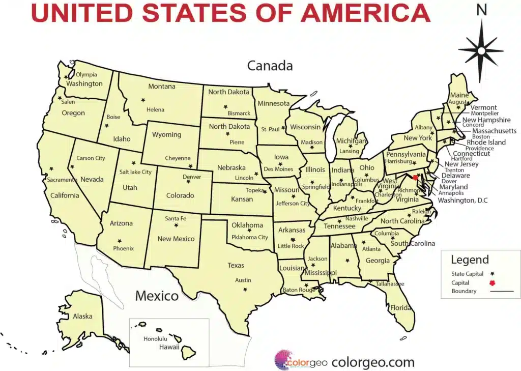
A Complete Map of USA and Mexico Free Download PDF/ESP/ai/SVG
The map of USA and Mexico is not just a geographical representation; it serves as a window into the rich history, cultural diversity, and economic ties between these two neighboring nations. In this article, we will explore the significance of the map of USA and Mexico, its features, and the valuable insights it provides. So, let’s embark on a journey across borders and delve into the intricacies of this fascinating map.

The Borders: A Tale of Two Nations
At the heart of the map of USA and Mexico lie the international borders that separate these two nations. The shared boundary stretches over 3,145 kilometers (1,954 miles), and it is a testament to the intertwined destinies and the flow of people, goods, and ideas between the USA and Mexico.
Exploring the Geography
The geography depicted on the map of USA and Mexico offers a glimpse into the diverse landscapes and topographical features of these countries. From the towering peaks of the Rocky Mountains to the vast deserts of the Southwest, and from the expansive plains of the Midwest to the tropical beaches along the Gulf of Mexico, the map captures the natural beauty that characterizes this region.
Download the Complete Map of USA and Mexico 5 different formats of PDF/ESP/ai/SVG
Map of USA and Mexico 5 different formats of SVG
Map of USA and Mexico 5 different formats of PDF
Map of USA and Mexico 5 different formats of EPS
Map of USA and Mexico 5 different formats of .ai
Cultural Mosaic: People and Heritage
The map of USA and Mexico not only outlines the physical boundaries but also showcases the rich cultural tapestry of these nations. With a population of over 330 million people in the USA and over 128 million in Mexico, the map represents a diverse blend of cultures, traditions, and languages. From the indigenous communities that have inhabited these lands for centuries to the vibrant immigrant communities that contribute to the cultural fabric, this map reflects the amalgamation of identities that shape the region.
Economic Interdependence
One cannot fully grasp the significance of the map of the USA and Mexico without understanding the economic ties that bind these two nations together. The North American Free Trade Agreement (NAFTA), now known as the United States-Mexico-Canada Agreement (USMCA), has fostered a thriving trade relationship between the USA and Mexico. The map serves as a visual representation of the interconnected supply chains, transportation networks, and cross-border commerce that drive economic growth and prosperity.
Importance in Politics and Governance
The map of USA and Mexico plays a crucial role in the realm of politics and governance. It delineates the jurisdictional boundaries, electoral districts, and administrative divisions that shape the governance structures in both countries. By understanding the map, policymakers and citizens can comprehend the distribution of power, the representation of diverse communities, and the complex dynamics of local, state, and federal governance.
Navigating the Map: Tools and Technology
In the digital age, the map of USA and Mexico has evolved beyond traditional paper formats. Technological advancements have given rise to interactive and dynamic maps that provide real-time information, satellite imagery, and geospatial data. Online platforms, mobile applications, and GPS devices have made navigation and exploration of the map more accessible, empowering individuals and businesses alike.
| States of the USA |
|---|
| Alabama |
| Alaska |
| Arizona |
| Arkansas |
| California |
| Colorado |
| Connecticut |
| Delaware |
| Florida |
| Georgia |
| Hawaii |
| Idaho |
| Illinois |
| Indiana |
| Iowa |
| Kansas |
| Kentucky |
| Louisiana |
| Maine |
| Maryland |
| Massachusetts |
| Michigan |
| Minnesota |
| Mississippi |
| Missouri |
| Montana |
| Nebraska |
| Nevada |
| New Hampshire |
| New Jersey |
| New Mexico |
| New York |
| North Carolina |
| North Dakota |
| Ohio |
| Oklahoma |
| Oregon |
| Pennsylvania |
| Rhode Island |
| South Carolina |
| South Dakota |
| Tennessee |
| Texas |
| Utah |
| Vermont |
| Virginia |
| Washington |
| West Virginia |
| Wisconsin |
| Wyoming |
Mexico is not divided into states; it is divided into 32 federal entities, which include 31 states and the capital, Mexico City. Here is a list of the federal entities in Mexico:
-
Aguascalientes
- Baja California
- Baja California Sur
- Campeche
- Chiapas
- Chihuahua
- Coahuila
- Colima
- Durango
- Guanajuato
- Guerrero
- Hidalgo
- Jalisco
- México (State of Mexico)
- Michoacán
- Morelos
- Nayarit
- Nuevo León
- Oaxaca
- Puebla
- Querétaro
- Quintana Roo
- San Luis Potosí
- Sinaloa
- Sonora
- Tabasco
- Tamaulipas
- Tlaxcala
- Veracruz
- Yucatán
- Zacatecas
- Mexico City (Ciudad de México)
As we conclude our exploration of the map of USA and Mexico, we recognize its significance as more than just lines on paper. It serves as a gateway to understanding the historical, cultural, economic, and political aspects that shape the relationship between these two nations. Whether you are an adventurer seeking to explore the diverse landscapes, a researcher investigating the sociopolitical dynamics, or a businessperson analyzing market opportunities, the map of USA and Mexico is an invaluable resource that unveils a world of possibilities.
