1970 Bhola Cyclone
The 1970 Bhola cyclone was a devastating tropical cyclone that struck East Pakistan (now Bangladesh) and India‘s West Bengal on November 12, 1970. It was the deadliest tropical cyclone ever recorded, and one of the deadliest natural disasters in modern times. Up to 500,000 people lost their lives in the storm, primarily as a result of the storm surge that flooded much of the low-lying islands of the Ganges Delta. This cyclone was the sixth cyclonic storm of the 1970 North Indian Ocean cyclone season, and also the season’s strongest, reaching a strength equivalent to a strong Category 3 hurricane.
The cyclone formed over the central Bay of Bengal on November 8 and traveled north, intensifying as it did so. It reached its peak with winds of 185 km/h (115 mph) on November 12 and made landfall on the coast of East Pakistan that night. The storm surge devastated many of the offshore islands, wiping out villages and destroying crops throughout the region.
Meteorological history of Bhola Cyclone
1. Storm path
The remnants of Tropical Storm Nora from the Pacific, which had lasted for two days in the South China Sea, moved west over the Malay Peninsula on November 5. The remnants of this system contributed to the development of a new depression in the central Bay of Bengal on the morning of November 8. The depression intensified as it moved slowly northward, and the India Meteorological Department upgraded it to a cyclonic storm the next day. The storm became nearly stationary that evening near 14.5° N, 87° E, but began to accelerate to the north on November 10.
The hurricane intensified into a severe cyclonic storm on November 11 and began to turn towards the northeast as it approached the head of the bay. A clear eye formed in the storm, and it reached its peak later that day with sustained winds of 185 km/h (115 mph) and a central pressure of 966 hPa, equivalent to that of a Category 3 hurricane on the Saffir-Simpson Hurricane Scale. The cyclone made landfall on the East Pakistan coastline during the evening of November 12, around the same time as the local high tide. Once over land, the system began to weaken but was still considered a cyclonic storm on November 13 when it was about 100 km (62 mi) south-southeast of Agartala. The storm then rapidly weakened into a remnant area of low pressure over southern Assam that evening.
2. Preparations for Bhola Cyclone
The Indian government received many ship reports from the Bay of Bengal that were giving meteorological information on the cyclone, but as Indo-Pakistani relations were generally hostile, the information was not passed on to the Pakistani government. A large part of the population was reportedly taken by surprise by the storm. There were indications that the storm warning system that existed in East Pakistan was not used properly, which may have cost tens of thousands of lives.
The Pakistan Meteorological Department issued a report calling for “danger preparedness” in the coastal regions in danger during the day on November 12. As the storm neared the coast, a “great danger signal” was broadcast on Pakistan Radio. Survivors later said that this meant little to them, but that they had recognized a No. 1 warning signal as representing the greatest possible threat. It is estimated that 90% of the population in the area was aware of the cyclone before it hit, but only about 1% sought refuge in fortified structures.
3. Impact of Bhola Cyclone
The coast of the Bay of Bengal is particularly vulnerable to the effects of tropical cyclones, and there have been at least six cyclones to hit the region that killed over 100,000 people in total. The 1970 Bhola cyclone was not the most powerful of these, however; the 1991 Bangladesh cyclone was significantly stronger when it made landfall in the same general area with 250 km/h (160 mph) winds, a high-end Category 4.
The 1970 cyclone is the deadliest tropical cyclone on record and is one of the deadliest natural disasters in recent history. The exact death toll will never be known, but it is estimated that between 300,000 and 500,000 people lost their lives. A comparable number of people died as a result of the 1976 Tangshan earthquake and the 2004 Indian Ocean earthquake, but because of uncertainty in the number of deaths in all three disasters, it may never be known which one was the deadliest.
As the storm made landfall, it caused a 10-meter (33 ft) high storm surge at the Ganges Delta. In the port at Chittagong, the storm tide peaked at about 4 m (13 ft) above the average sea level, 1.2 m (3.9 ft) of which was the storm surge. The devastation was complete throughout the southern half of Bhola Island, and the rice crops of Bhola Island, Hatia Island and the nearby mainland coastline were destroyed.
Several seagoing vessels in the ports of Chittagong and Mongla were reported damaged. The airports at Chittagong and Cox’s Bazar were under 1 m (3.3 ft) of water for several hours. Over 3.6 million people were directly affected by the cyclone the total damage from the storm was estimated at $86.4 million (1970 USD, $450 million 2006 USD). The survivors claimed that approximately 85% of homes in the area were destroyed or severely damaged. Of the 77,000 onshore fishermen, 46,000 were killed by the cyclone, and 40% of the survivors were affected severely.
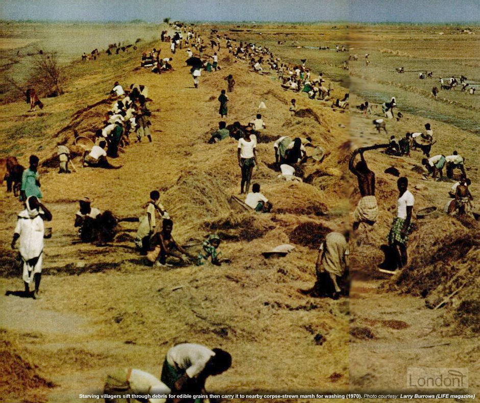
Agricultural damage was similarly severe with the loss of $63 million worth of crops and 280,000 cattle. Three months after the storm, 75% of the population was receiving food from relief workers, and over 150,000 relied upon aid for half of their food.
4. Death toll
The mortality was estimated at 14.2%—equivalent to a death toll of 240,000. Cyclone-related morbidity was generally restricted to minor injuries, but a phenomenon dubbed “cyclone syndrome” was observed. This consisted of severe abrasions on the limbs and chest caused by survivors clinging to trees to withstand the storm surge. Initially, there were fears of an outbreak of cholera and typhoid fever in the weeks following the storm, but the survey found no evidence of an epidemic of cholera, smallpox, or any other disease in the region affected by the storm
5. Aftermath: Criticism of government response
We have a large army, but it is left to the British Marines to bury our dead. Sheikh Mujibur Rahman Political leaders in East Pakistan were deeply critical of the central government’s initial response to the disaster. A statement released by eleven political leaders in East Pakistan ten days after the cyclone hit charged the government with “gross neglect, callous indifference, and utter indifference”.
They also accused the president of playing down the news coverage. On November 19, students held a march in Dhaka in protest of the speed of the government response, and Maulana Abdul Hamid Khan Bhashani addressed a rally of 50,000 people on November 24, when he accused the president of inefficiency and demanded his resignation. The president’s political opponents accused him of bungling the efforts and some demanded his resignation.
6. International response
India became one of the first nations to offer aid to Pakistan, despite the generally poor relations between the two countries, and by the end of November had pledged $1.3 million (1970 USD, $6.9 million 2007 USD) of assistance for the relief efforts. US President Richard Nixon allocated a $10 million (1970 USD, $53 million 2007 USD) grant to provide food and other essential relief to the survivors of the storm.
The Canadian government pledged $2 million of assistance. France and West Germany sent both helicopters and various supplies worth $1.3 million. The Japanese cabinet approved a total of $1.65 million of relief funds in December. The Japanese government had previously drawn criticism for only donating a small amount to relief work. The first shipment of Chinese supplies to East Pakistan was a planeload of 500,000 doses of cholera vaccine, which was not necessary as the country had adequate stocks.
The Chinese government sent $1.2 million in cash to Pakistan. The United Nations donated $2.1 million in food and cash, whilst UNICEF began a drive to raise a further million.UNICEF helped to re-establish water supplies in the wake of the storm, repairing over 11,000 wells in the months following the storm. UN Secretary-General U Thant made appeals for aid for the victims of the cyclone and the civil war in August, in two separate relief programs. He said only about $4 million had been contributed towards immediate needs, well short of the target of $29.2 million.
By the end of November, the League of Red Cross Societies had collected $3.5 million to supply aid to the victims of the disaster. The World Bank estimated that it would cost $185 million to reconstruct the area devastated by the storm.
7. The Concert for Bangladesh
In 1971, ex-Beatle George Harrison was inspired to organize The Concert for Bangladesh, in part from the 1970 Bhola Cyclone, and from the 1971 Bangladesh atrocities and Bangladesh Liberation War. Although it was the first benefit concert of its type, it was vastly successful in raising money, aid, and awareness for the region’s plight.
List of Bangladesh tropical cyclones including Bhola Cyclone
Bangladesh, due to its unique geographic location, suffers from devastating tropical cyclones frequently. The funnel-shaped northern portion of the Bay of Bengal causes tidal bores when cyclones make landfall, and thousands of people living in the coastal areas are affected.
Some of the most devastating natural disasters in recorded history with high casualties were tropical cyclones that hit the region now forming Bangladesh. Among them, the 1970 Bhola cyclone alone claimed more than 500,000 lives.
Historical records: List of Bangladesh tropical cyclones including Bhola Cyclone
- 1584: A five-hour hurricane and thunderstorm destroyed houses and boats in the coast near Bakerganj (presently in Barisal) and Patuakhali). Only Hindu temples with a strong foundation were spared. Total casualty: about 200,000.
- 1585: A tropical storm hit the eastern side of Bakerganj (now Barisal) near the mouth of the Meghna River estuary, causing the devastation of crops. Casualty: unknown.
- November 1797: A severe cyclone destroyed most of the houses in Chittagong) region. Two ships sank in Chittagong Port.
- May 1822: A cyclone, accompanied by storm surge and tidal bores hit Barisal, Hatiya Island and Noakhali. Casualty: 40,000 people.
- October 1831 Barisal: Casualty: unknown.
- October 1872: A cyclone hit Cox’s Bazar. Casualty: unknown.
- 31 October 1876: A cyclone with a storm surge of 12.2 meters (40 ft) hit the Meghna River estuary near Chittagong, Barisal, and Noakhali. Casualty: about 200,000. The storm also caused epidemic and famine, and vast property damage.
- 24 October 1897 Chittagong: A tropical cyclone accompanied by storm surge hit the area hard, especially near the Kutubdia island. Casualty: 14,000. The resulting epidemic of Cholera killed another 18,000.
- May 1898 Teknaf: Tropical cyclone with storm surge. Casualty: unknown.
- November 1904 Sonadia: cyclonic storm; 143 killed and fishing fleet wrecked.
- 16 October 1909 Khulna: A tropical cyclone accompanied by storm surge. Casualty: 698 people and 70,654 cattle.
- October 1913 Muktagachha upazila (Mymensingh District): A tropical cyclone, having moved inland destroyed villages. Casualty: 500 people.
- 24 September 1917 Khulna. A tropical cyclone. Casualty: 432 people and 28,029 cattle.
- May 1941: A cyclonic storm accompanied by storm-surge hit the Eastern Meghna River estuary. Casualty: unknown.
- October 1942: A severe cyclonic storm hit The Sundarbans. Casualty: unknown.
- 17–19 May 1948: A cyclonic storm hit the delta between Chittagong and Noakhali. Casualty: approximately 1,200 people and 20,000 cattle.
- 16–19 May 1958: A cyclonic storm accompanied by storm surge hit east and west Meghna River estuary, east of Barisal and Noakhali. Casualty: 870 people and 14,500. Also standing crops were destroyed.
- 21–24 October 1958: A cyclonic storm struck the Chittagong coast. Effect: Approx. 100,000 families were rendered homeless.
- 9–10 October 1960: A severe cyclonic storm hit the Eastern Meghna River estuary near Noakhali, Bakerganj, Faridpur and Patuakhali. The storm had wind speeds of up to 201 km/hour. The maximum storm surge was 3.05 meters. It caused devastating damage in Char Jabbar, Char Amina, Char Bhatia, Ramgati, Hatiya and Noakhali. Casualty: 3,000 people. Other effects: 62,725 houses destroyed. Crops on 94,000 acres (380 km²) of land were destroyed.
- 30–31 October 1960: A severe cyclonic storm hit Chittagong, Noakhali, Bakerganj, Faridpur, Patuakhali and eastern Meghna estuary, with winds speed up to 210 km/h. The storm surge reached a height of 4.5-6.1 m. Casualty: about 10,000 people, 27,793 cattle . Losses: 568,161 houses destroyed (including 70% houses in Hatiya). Also, two large ocean-going ships ran aground in the shore, and 5-7 vessels capsized in Karnaphuli River.
- 9 May 1961: A severe cyclonic storm hit Bagerhat and Khulna. It had wind speeds of up to 161 km/h. The storm surge reached 2.44-3.05 m. Casualty: 11,468 people (mostly in Char Alexander), 25,000 cattle. Damages: The railway tracks between Noakhali and Harinarayanpur were damaged.
- 26–30 October 1962: A severe cyclone hit Feni. Maximum windspeed was 161 km/h. The storm surge was 2.5-3.0 m. Casualty: about 1,000 people, many domestic cattle.
- 28–29 May 1963: A severe cyclonic storm devastated Chittagong, Noakhali, Cox’s Bazar and coastal islands of Sandwip, Kutubdia, Hatiya and Maheshkhali. The storm surge reached 4.3-5.2 m in Chittagong. Maximum windspeed was up to 203 km/h and at Cox’s Bazar 164 km/h. Casualty: 11,520 people, 32,617 cattle. Damages: 376,332 houses, 4,787 boats, and standing crops.
- 11–12 May 1965: A strong cyclone hit Barisal and Bakerganj. The windspeed reached a maximum of 162 km/h. The storm surge was 3.7 m. Casualty:19,279 people (out of that, 16,456 in Barisal).
- 14–15 December 1965: A strong cyclone hit the coast near Cox’s Bazar and Patuakhali. The storm surge rose up to 4.7-6.1 m. The windspeed was up to 210 km/h in Cox’s Bazar. Casualty” 873 people. Damage: 40,000 salt beds were destroyed.
- 1 October 1966: A cyclone hit Sandwip, Bakerganj, Khulna, Chittagong, Noakhali, and Comilla. The maximum strong surge was 4.7-9.1 m. The maximum wind speed was 146 km/h. Total people affected: 1.5 million people. Casualty: 850 people, 65,000 cattle.
- 12 November 1970: The 1970 Bhola cyclone hit the entire coast of Bangladesh (then East Pakistan). The most affected were Chittagong, Barguna, Khepupara, Patuakhali, north of Char Burhanuddin, Char Tazumuddin and south of Maijdi, Haringhata. The official death toll was 500,000 but the number is likely to be higher. Damages include the destruction of approximately 20,000 fishing boats, and also property and crops. Total loss of cattle reached more than one million. More than 400,000 houses and 3,500 educational institutions were destroyed. Maximum windspeed reached about 222 km/h. The maximum storm surge was about 10.6 m.
- 5–6 November 1971: A cyclone hit coastal areas of Chittagong.
- 28–30 November 1971: A cyclonic storm hit the coast near the Sundarbans. Maximum wind speed was 97–113 km/h. The storm surge reached 1 m. Low-lying areas of Khulna town were inundated.
- 6–9 December 1973: The coastal areas near the Sundarbans were hit by a cyclone, accompanied by a storm surge. Coastal areas near Patuakhali and nearby islands were submerged under the tidal bore.
- 13–15 August 1974: A cyclonic storm hit Khulna. Maximum wind speed reached 80.5 km/h. Casualty:600 people.
- 24–28 November 1974: A cyclone struck the coastal areas near Cox’s Bazar and Chittagong, including the offshore islands. Maximum wind speed reached 161 km/h. The storm surge was up to 2.8-5.2 m. Casualty: 200 people, 1000 cattle. Damages: 2,300 houses destroyed.
- 9–12 May 1975: A strong cyclone pummeled Bhola, Cox’s Bazar and Khulna. Maximum wind speed was 96.5 to 112.6 km/h. Casualty: 5 people.
- 9–12 May 1977: Khulna, Noakhali, Patuakhali, Barisal, Chittagong and offshore islands were hit by a cyclone. Maximum wind speed was up to 112.63 km/h.
- 14–15 October 1983: A strong cyclone hit the coastal islands and chars near Chittagong and Noakhali. Maximum wind speed reached 122 km/h: Casualty: 43 people. 6 fishing boats and a trawler were lost, and more than 150 fishermen and 100 fishing boats went missing Damages: 20% of the aman rice crops in the affected regions were destroyed.
- 5–9 November 1983: A cyclone hit Chittagong, Cox’s Bazar coast near Kutubdia, St Martin’s Island, Teknaf, Ukhia, Moipong, Sonadia, Barisal, Patuakhali and Noakhali. The maximum wind speed reached 136 km/h. The storm surge was 1.52 m. Casualty:300 fishermen with 50 boats missing. Damages:2,000 houses destroyed.
- 24–25 May 1985: A severe cyclone hit Chittagong, Cox’s Bazar, Noakhali, and coastal islands (Sandwip, Hatiya, and Urirchar). Maximum wind speed at Chittagong was 154 km/h, at Sandwip was 140 km/h, at Cox’s Bazar was 100 km/h. The storm surge reached a height of 3.0-4.6 m. Casualty:11,069 people, 135,033 cattle. Damages: 94,379 houses and 74 km of road, and embankments destroyed.
- 8–9 November 1986: A severe cyclonic storm hit the coastal island and chars near Chittagong, Barisal, Patuakhali and Noakhali. Maximum windspeed was 110 km/h at Chittagong and 90 km/h at Khulna. Casualty: 14 people. Damages: 972 km² of paddy fields were inundated; Schools, mosques, warehouses, hospitals, houses and buildings were destroyed at Amtali upazila in Barguna District.
- 24–30 November 1988: A severe cyclonic storm struck Jessore, Kushtia, Faridpur, and the coastal islands of Barisal and Khulna. The maximum windspeed was 162 km/h. The storm was accompanied by a storm surge of 4.5 m at Mongla Port. Casualty: 5,708 people, and numerous wild animals at The Sundarbans (deer 15,000, Royal Bengal Tiger 9), cattle 65,000. Total damage to crops reached Taka 9.41 billion.
- 29–30 April 1991: The 1991 Bangladesh cyclone hit Bangladesh late 29 April night. The storm originated in the Indian Ocean and reached the Bay of Bengal coast after 20 days. The diameter of the storm was close to 600 km. The maximum wind speed (observed at Sandwip) reached 225 km/h. At other places, the maximum wind speed was reported as follows: Chittagong 160 km/h, Khepupara (Kalapara) 180 km/h, Kutubdia 180 km/h, Cox’s Bazar 185 km/h, and Bhola 178 km/h. (The NOAA-11 satellite estimated the maximum wind speed to be about 240 km/h at 1.38 pm on 29 April). The storm made landfall near the coast north of Chittagong port during the night of the 29th of April. The maximum storm surge height reached about 5 to 8 m. Casualty: 150,000 people, 70,000 cattle. Damages: loss of property was estimated at about Tk 60 billion.
- 31 May-2 June 1991: A cyclone hit the coastal islands and chars near Patuakhali, Barisal, Noakhali and Chittagong. Maximum wind speed reached 110 km/h. The storm surge was 1.9 m.
- 29 April-3 May 1994: A severe cyclonic storm hit the coastal islands near Cox’s Bazar. Maximum windspeed reached 210 km/h. Casualty: 400 people, 8,000 cattle.
- 21–25 November 1995: A severe cyclonic storm hit the coastal islands near Cox’s Bazar. The maximum wind speed was up to 210 km/h. Casualty: 650 people, 17,000 cattle.
- 16–19 May 1997: A severe cyclonic storm hit the coastal islands and chars near Chittagong, Cox’s Bazar, Noakhali and Bhola districts. The maximum wind speed was 225 km/hour, and the storm surge reached 3.05 meters. Casualty: 126 people.
- 25–27 September 1997: A severe cyclonic storm hit coastal islands near Chittagong, Cox’s Bazar, Noakhali and Bhola. It had wind speeds of up to 150 km/hour and a storm surge of 1.83 to 3.05 meters.
- 16–20 May 1998: A severe cyclonic storm with a windspeed of 150 km/hour struck coastal islands near Chittagong, Cox’s Bazar, and Noakhali. The storm surge was from 1.83 to 2.44 meters.
- 19–22 November 1998: A cyclonic storm, with wind speeds up to 90 km/hour, and a storm surge of 1.22 to 2.44 metres. hit coastal islands and sand shoals near Khulna, Barisal, and Patuakhali.
- November 15, 2007: Cyclone Sidr makes landfall in southern Bangladesh, causing over 2,000 deaths and severe damage.
CYCLONE “SIDR” OF 15 NOVEMBER 2007 IN BANGLADESH
Cyclone “SIDR” was one of the 10 strongest cyclones to hit Bangladesh between 1876 and 2007. “SIDR” developed in the Bay of Bengal in early November 2007. It further intensified into a category 4 storm system (on the Saffir-Simpson Scale) with peak sustained winds of up to 215 km/h (135 mp/h) (peaking at 260 km/hour). The cyclone made landfall in Bangladesh in the evening of November 15, 2007. SIDR and its surge resulted in thousands of deaths and massive destruction of coastal communities.
# Formation and Path of Cyclone “SIDR”
9 November 2007- An air mass disturbance with weak low-level circulation begun developing in the central Bay of Bengal, southeast of the Andaman islands, in close proximity to the Nicobar Islands. Moderate upper-level wind shear inhibited its organized development, however strong diffluence aloft aided in developing convection. 11 November 2007- The anomalous weather system was still somewhat south of the Andaman Islands.
A better-defined cyclonic circulation developed when the vertical shear begun decreasing. Based on that development, a “Tropical Cyclone Formation Alert” was issued for the region. Later that day, when winds reached 65 km/h (40 mph), the India Meteorological Department (IMD) designated the system as a Tropical Depression.
Still later on November 11, the system intensified as it moved slowly in a north-westward direction. The Joint Typhoon Warning Center (JTWC) upgraded it to the designation of Tropical Cyclone. 12 November 2007 – As the system further intensified, the India Meteorological Department (IMD) further upgraded the weather system to a ” severe cyclonic storm” and named it “SIDR”.
# SIDR’s Landfall “SIDR”
15 November 2007- By the morning of 15 November 2007, Cyclone “SIDR” had moved considerably northward towards India’s eastern border with Bangladesh. It had strengthened to reach Category-4 tropical cyclone status, with peak sustained winds of 215 km/h (135 mp/h). According to the JTWC best track, “SIDR” subsequently reached peak wind velocities of up to 260 km/h.
Later that day, it appeared that the cyclone’s brunt of force would be felt by the less populated areas known as “Sundarbans”, the mangrove forest that stretches along the western third of Bangladesh’s coast – a world heritage site that is home to the rare Royal Bengal Tigers. However, this did not happen. Around 1700 UTC that day, with still sustained winds of 215 km/h (135 mph), SIDR made direct landfall in the district of Bagerha, a highly-populated area of Bangladesh. A catastrophic surge flooded the area and caused most of the deaths and damage.
16 November 2007- By November 16, “SIDR” weakened considerably as it moved over land.
Two NASA satellite photos show Cyclone “SIDR” as it approaches the coast of Bangladesh.
# The Cyclone Surge “SIDR”
Bangladesh is a country that is almost entirely situated on an enormous delta that has been formed by the confluence of Ganges, Brahmaputra, and Meghna rivers and their tributaries. This extensive river system is constantly fed by waters of melting snow from the Himalayan mountains. Thus, the entire country is mostly flat and extremely vulnerable to flooding. Cyclone “SIDR” generated maximum flooding. The cities of Patuakhali, Barguna, and Jhalokati District were hit hard by the storm surge that was over 5 meters (16 ft) In height. Fortunately, the cyclone made landfall when the tide was low, so the surge was not as high as it could have been.
# Death Toll and Damages “SIDR”
Most of the cyclones that have made landfall in Bangladesh in the past have caused thousands of deaths. “SIDR” was no exception. According to official accounts 3,447 people lost their lives. However, this is believed to be inaccurate. The actual death toll may never be known with certainty. It is estimated that perhaps up to 10,000 people actually lost their lives, with thousands more injured, or missing. Thousands more were displaced and became homeless.
The damage in Bangladesh was extensive. About a quarter of the World Heritage Site “Sunderbans” was damaged. The entire cities of Patuakhali, Barguna and the Jhalokati District were hit hard by the cyclone’s surge of over 5 meters (16 ft).
There was extensive flood damage at Barisal and at Baniashanta, across from the port city, Mongla, as the cyclone’s surge rolled in. In the town of Mothbaria, one of the towns in the very center of the devastation, there was hardly anything left standing, except for a few brick and concrete buildings. Houses and schools were demolished. The storm’s surge washed away all roads in the region. About 500 fishing boats were unaccountable and over 3,000 fishermen were reported missing.
Much of the capital city of Dhaka was also severely affected due to the winds and the flooding which affected the city’s infrastructure. Electricity and water service were cut.
The agricultural industry of Bangladesh was devastated by the flooding which covered about 1 million hectares of farmable land. In brief, “SIDR” affected about 2 million families comprising about 9 million people. More than 1.5 million homes were destroyed.


More Stories
What is an Aquifer?
Explain How Groundwater is Recharged
Study in Japan after HSC for Bangladeshi